SHORELINE PROCESSES AND THE EVOLUTION OF COASTAL LANDFORMS
WATER
WAVES are
another agent of an EROSION, TRANSPORTATION and DEPOSITION of
sediments.
Along the shores of oceans and lakes waves break against the land building it up in some places (depositing sediments) and tearing it down in others (eroding).
The
ENERGY of the WAVES comes from the WIND.
|
Energy
is used to: |
ERODE TRANSPORT SEDIMENTS DEPOSIT |
WAVE
Alternating rise and fall of the water surface, produced by the flow of wind
across the water surface.
Small
local differences in air pressure create ondulations in the water surface.
It’s
important to understand how waves travel and move sediments.
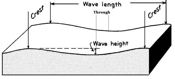
Waves are described or characterized by
WAVELENGHT
|
Distance between identical parts of the
wave. |
CREST
|
Highest
portion of the wave with respect to the horizontal |
THROUGH
|
Lowest
portion of the wave with respect to the horizontal |
PERIOD
|
Time
it takes identical parts of successive waves to pass a fixed reference point |
HEIGHT
|
Vertical
distance between the crest and the through. It
is a key factor in determining wave energy OPEN
OCEAN 2-5 m HURRICANE 15 m or more HIGHEST
EVER 34 m (112 ft) Waves
travel between 30-90 km/hour |
TSUNAMI. Results from a sudden displacement of seafloor (earthquake; fault; the collapse of a caldera)
Wave height in open sea; 1 m or
so.
Wavelength in open sea; 100 to 200 km.
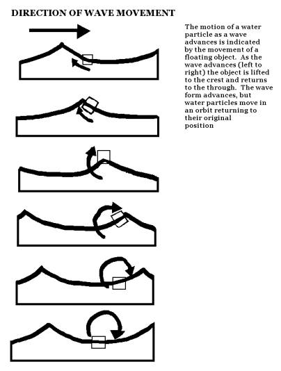
MOVEMENT IN WATER IN A WAVE
A particle of water moves in an orbit or circular path as the waves passes. The particle essentially returns to its original position after the wave has passed.
|
AT
THE SURFACE |
The
diameter of the orbital path is equal to the height of the wave. |
|
BELOW
THE SURFACE |
The
orbit decreases in size until the motion is essentially gone at a depth equal
to ½ of the wavelength. This is the WAVE BASE |
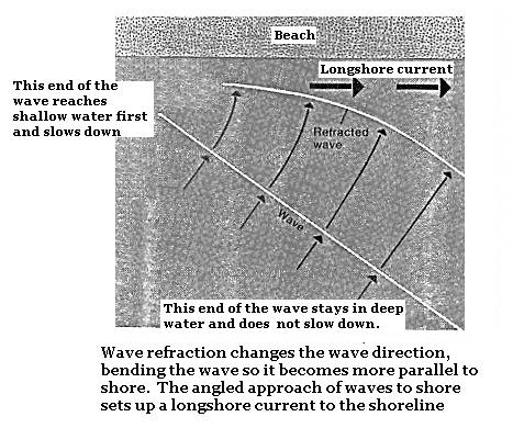
WAVE REFRACTION
Most
waves do not strike the shore directly, but rather meet it at an angle. When a wave approaches the coast in this
manner, one end of the wave encounters shallow water first and slows down,
while the rest of the waves is still in deeper water. Thus the part of the wave close to the shore slows down while the
remainder continues to advance at a con tact speed. As a result the wave close to the shore bend. This process is called REFRACTION
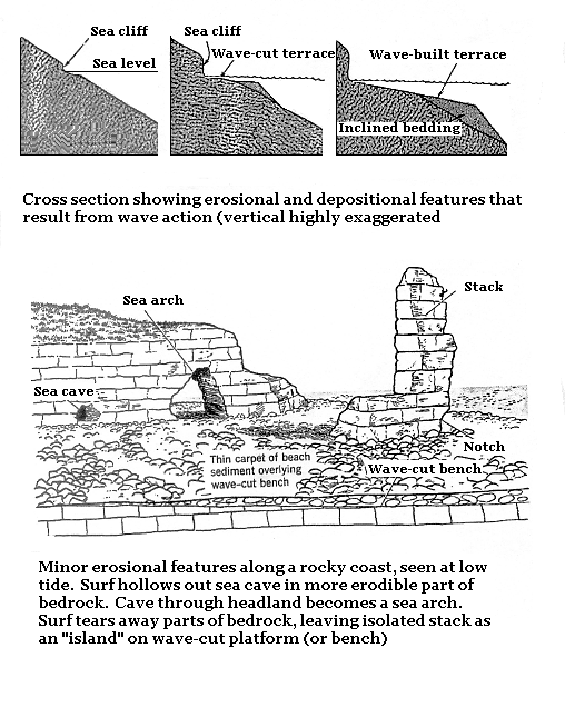
WAVE EROSION
Occurs
at sea level. Undercuts exposed
bedrock.
Waves break directly o the shoreline, and thus expend the greatest part of their energy in eroding land.
FEATURES CAUSED BY
WAVE EROSION
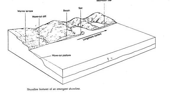
|
WAVE-CUT CLIFF |
Formed by waves pounding against a rocky coastline |
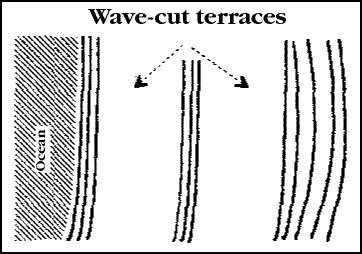
|
WAVE-CUT TERRACE or PLATFORM |
Formed at the foot of a cliff. Formed by wave erosion pushing the Wave-cut cliff steadily back. |
|
Features resulting from differential erosion of weaker sections of the rock |
|
|
SEA NOTCHS |
Wave action may hollow out cavities |
SEA CAVES |
|
|
SEA ARCHS |
When erosion, cuts through a headlands |
|
SEA STACKS |
The collapse of the roof of a sea arch leaves an isolated mass of rock, in the front of the cliff. |
Since the surging water of the breaking waves must cross this terrace before reaching the cliff, it looses a certain amount of energy through turbulence and friction. So the farther the cliff retreats the less effective are the waves eroding the cliff. If the sea level remains constant, the retreat of the cliff becomes slower and slower.
EROSIONAL FEATURES
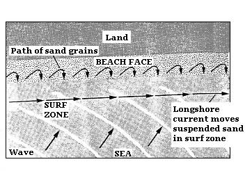
SEDIMENT TRANSPORT
Sediment is transported along the shore in a ZIGZAG pattern during the
wash-backwash flow of the water. After
the waves has washed up as far as it can go, the water returns to se by running
down the beach face by the shortest possible route; straight downhill to the
shoreline not back along the oblique route it came up (refraction). The net effect of this motion is to move the
sand along the beach face. This
transportation process is called LONG-SHORE
DRIFT or CURRENT.
FEATURES CAUSED BY DEPOSITION OF SEDIMENTS
BEACH
|
Any strip of sediment that extends from the low-water line inland to a cliff or zone of permanent vegetation. Built of material eroded by waves from the headlands, and material brought down by rivers that carry the products of weathering and erosion from the land masses. Areas
that are protected from the full force of water waves. It’s continually modified by wave and
current erosion. |
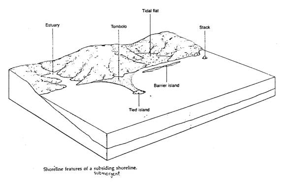
SPIT
|
A
narrow ridge or embankment of sediment forming a finger-like projection from
the shore into the open ocean. Typically
develops when the sediment being carried by long-shore drift is deposited where
water becomes deeper, such as the mouth of a bay. |
|
BAYMOUTH BAR or BAY
BARRIER |
A
ridge, commonly exposed, of sand extending partially |
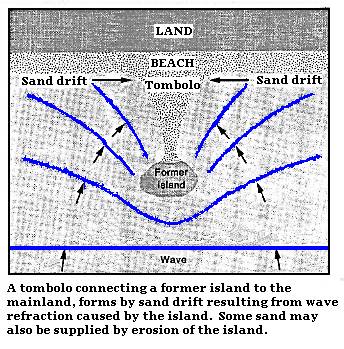
|
TOMBOLO TIED ISLAND |
Beach
of sand or sand that connects two islands or an island with mainland. |
BARRIER ISLAND
(Atlantic
City, NJ; Miami Beach, FL; and Galveston, TX) |
Breached
baymouth bar. Most
common North America feature of the East coast. 1300 km from Long Island to Florida and the Gulf Coast (295) First
line of defense against storm waves and hurricane. |
LAGOONS
|
Isolated
bays |
DEPOSITIONAL FEATURES

MAIN TYPES OF COASTLINES
SUBMERGENT
|
Flooded |
Sea-level
is relatively raised |
|
EMERGENT |
Exposed |
Sea
level is relatively lowered. |
TWO MAIN TYPES OF COASTLINE
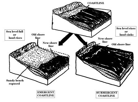
SUBMERGENT COASTLINES.
Previously
dry land that has been recently drowned either by land subsidence or a rise in sea
level. Their appearance is controlled by the erosional processes prior to the
rise of the sea level. Irregular
coastlines.
EROSIONAL
PROCESS PRIOR TO THE RISE OF SEA
|
TYPE / Features
|
STREAM EROSION
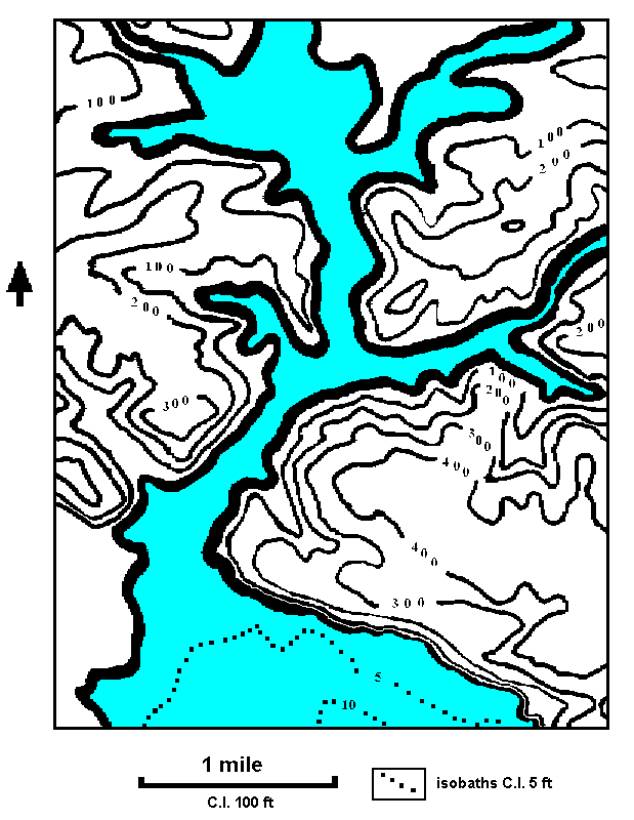
|
ESTUARIES
They extend
inland
Flooded stream
valley
V-shaped passages. Fresh-water
from the river mixes with sea-water (brackish water) Protected
environment. Reach
marine life |
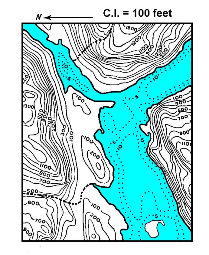
GLACIAL EROSION
|
FJORDS
They extend inland. Flooded glacial
valley
Forms very steep passages (U-shaped). Deep
long narrow arm of he sea surrounded by high rocky cliffs or mountainous
slopes Very
rugged shoreline. |
SUBMERGENT COASTLINES
SUBMERGENT COAST MAP (ESTUARY)
SUBMERGENT COAST MAP (FJORD) MAP
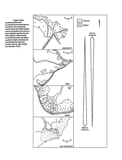
DELTA.
A delta is a thick accumulation of sediments at the mouth of a river.
As the shoreline is built has built outward, the river has shifted from one position to another.
This deposition has made the area so flat that the river has commonly split into a number of channels, each of which carries a part of the river water into the ocean (The Gulf). These are called DISTRIBUTARIES (PASSES).
Part of the sediment brought down b the distributaries is accumulated in the form of offshore islands (sand bars).
Waves and tides will modify and remove some of the delta front.
MISSISSIPPI RIVER DELTA. Each year the river discharges water into the Gulf at an average rate of 15,360 m3 per second with 684,528,300 tons of sediment (at the active Balize Delta Lobe). Dariry average discharge of 1-1.5 million tons of sediments)
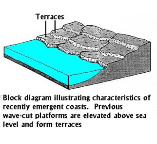
EMERGENT COASTLINE
Land formed under water that recently has become dry land, either by uplift of the land or drop of the sea level.
Generally straight
Characterized by the presence of extensive elevated Wave-Cut Platforms, Terraces or Platforms and Wave cut cliffs.
Erosion is the dominant agent.
EMERGENT COAST (SIMPLIFIED) MAP
STAGES OF COAST
MODIFICATION (SUBMERGENT COASTLINES)
When waves break against headlands most of their energy dissipates. Therefore the waves inside adjacent bays have lower energy and as a result sediments are deposited in the bays. As headlands erode and bays fill with sediment, an irregular coastline eventually becomes smooth
EARLY |
Erosional features are dominant Landforms: sea cliffs and stacks, wave-cut platforms, etc. Depositional features not common. Highly irregular coastline |
MIDDLE |
Depositional features begin to appear; beaches, spits. Broad wave-cut platforms are common |
|
LATE |
Depositional features are dominant. Landforms: extended spits, Baymouth bars, beaches, Lagoons, etc. Reduced headlands. Nearly linear shorelines. |