| EENS 204 | Natural Disasters |
| Tulane University | Prof. Stephen A. Nelson |
Exceptional Weather (Part 2) |
|
Hurricanes (Tropical Cyclones) Hurricanes are massive tropical cyclonic storm systems with winds exceeding 119 km/hr (74 miles/hour). The same phenomena is given different names in different parts of the world. In the western Pacific they are called typhoons, and in the southern hemisphere they are called cyclones. But, no matter where they occur they represent the same process. Hurricanes are dangerous because of their high winds, the storm surge produced as they approach a coast, and the severe thunderstorms associated with them. Although death due to hurricanes has decreased in recent years due to better methods of forecasting and establishment of early warning systems, the economic damage from hurricanes has increased as more and more development takes place along coastlines. It should be noted that coastal areas are not the only areas subject to hurricane damage. Although hurricanes loose strength as they move over land, they still carry vast amounts of moisture onto the land causing thunderstorms with associated flash floods and mass-wasting hazards. Origin of Hurricanes
|
|
|
|
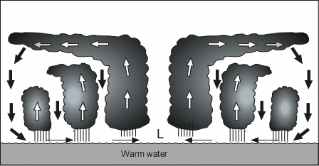
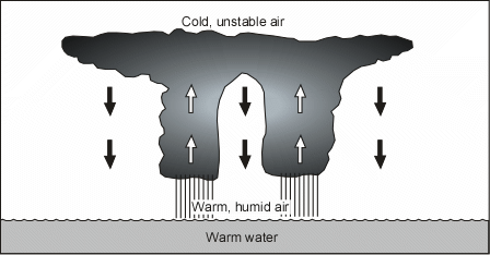
To undergo these steps to form a hurricane, several environmental conditions must first be in place:
|
|
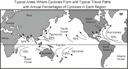
| Hurricanes thus commonly develop in areas near, but not at the equator, as shown in
the diagram below. As they move across the oceans their paths are steered by the
presence of existing low and high pressure systems, as well as the Coriolis force. The
latter force causes the storms to eventually start turning to the right in the northern
hemisphere and to the left in the southern hemisphere. Note that about 12% of all tropical cyclones develop in the Atlantic Ocean. Those that begin to form near the coast of Africa are often referred to as "Cape Verde" hurricanes, because the area in which they develop is near the Cape Verde Islands. 15% of all tropical cyclones develop in the eastern Pacific Ocean, 30% develop in the western Pacific Ocean, 24% in the Indian Ocean both north and south of the equator, and 12% develop in the southern Pacific Ocean. It is notable that essentially no tropical cyclones develop south of the Equator in the Atlantic Ocean. |
|
| Hurricane Structure | |
| Because the converging winds spiral inward toward the central low pressure area, the winds rotate in a counterclockwise direction around the central low in the northern hemisphere (clockwise in the southern hemisphere). As these winds spiral inward they draw in the thunderclouds around the storm, creating the spiral rain bands that are clearly visible on satellite images of the storm (see figure 11.1, page 303 in your text, or the image on the EENS 204 home page). |
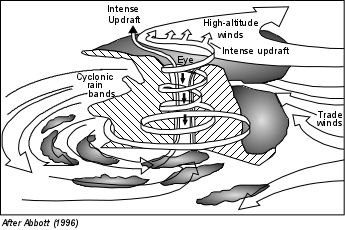 |
| As the winds converge toward the central core, they spiral upwards, sending warm moist
air upwards. As this air rises, it cools and releases its latent heat into the
atmosphere to add further energy to the storm. The winds spiraling around this
central core create the eye of the tropical cyclone and eventually
spread out at high altitudes. Eventually, cool air above the eye begins to sink into
the central core. This dry descending air within the eye gives the core a clear,
cloud free sky, with little to no wind. Since the main source of energy for the
storm is the heat contained in the warm tropical and subtropical oceans, if the storm
moves over the land, it is cut off from its source of heat and will rapidly dissipate. |
|
|
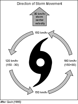
Winds spiraling counterclockwise (in the northern hemisphere) into the eye of the hurricane achieve high velocities as they approach the low pressure of the eye. The velocity of these winds is called the hurricane-wind velocity. The central low pressure center of the eye also moves across the surface of the Earth as it is pushed by regional winds. The velocity at which the eye moves across the surface is called the storm center velocity. Thus, when we consider the velocity of winds around the hurricane we must take into account both the wind velocity and the storm center velocity. Depending on the side of the hurricane, these velocities can either add or subtract. In the example at the left, the hurricane is traveling north with a storm center velocity of 30 km/hr, and a hurricane-wind velocity of 150 km/hr. On the right hand side of the storm both velocities are to the north so the total wind velocity is 180 km/hr (30 + 150). On the left hand side of the storm, however, the wind is blowing to the south. |
| Thus, since the storm is moving in the opposite direction to the winds, the velocities subtract and the total wind velocity is 120 km/hr (150 - 30). This is an important point. Winds are always stronger on the right side of a moving hurricane in the northern hemisphere. (The opposite is true in the southern hemisphere, since winds circulate in a clockwise direction, the winds are stronger on the left-hand side of the storm in the southern hemisphere). |
|
Tropical Cyclone Size Since winds spiral inward toward the central low pressure area in the eye of a hurricane, hurricane-wind velocity increases toward the eye. The distance outward from the eye to which hurricane strength winds occur determines the size of the hurricane. Winds in the eye wall itself have the highest velocity and this zone can extend outward from the center to distances of 16 to 40 km. Hurricane force winds (winds with velocities greater than 119 km/hr) can extend out to 120 km from the center of the storm. The largest tropical cyclone recorded, Typhoon Tip, had gale force winds (54 km/hr) which extended out for 1100 km in radius in the Northwest Pacific in 1979. The smallest, Cyclone Tracy, had gale force winds that only extended 50 km in
radius when it struck Darwin, Australia, in 1974. There is very little association
between hurricane intensity (either measured by maximum sustained winds or by
central pressure) and size. Hurricane Andrew is a good example of a very intense
tropical cyclone of small size. It had 922 mb central pressure and 230 km/hr
sustained winds at landfall in Florida, but had gale force winds extending out to only
about 150 km from the center. |
| Hurricane Intensity and Frequency Once a hurricane develops, the Saffir-Simpson Scale is used to classify a hurricane's intensity and damage potential. There are five possible categories. Category 1 storms are more common than category 5 storms. In a typical year, there may be many category 1 storms, but category 5 storms occur very infrequently. |
Saffir-Simpson Hurricane Damage-Potential Scale |
||||
Scale Number |
Central Pressure |
Wind Speeds |
Storm Surge |
Observed |
| 1 | >980 (>28.94) |
74-95 (119-153) |
4-5 (1.2-1.5) |
some damage to trees, shrubbery, and unanchored mobile homes |
|---|---|---|---|---|
| 2 | 965-979 (28.50-28.91) |
96-110 (154-177) |
6-8 (1.8-2.4) |
major damage to mobile homes; damage buildings' roofs, and blow trees down |
| 3 | 945-964 (27.91-28.47) |
111-130 (178-209) |
9-12 (2.5-3.6) |
destroy mobile homes; blow down large trees; damage small buildings |
| 4 | 920-944 (27.17-27.88) |
131-155 (210-249) |
13-18 (3.9-5.5) |
completely destroy mobile homes; lower floors of structures near shore are susceptible to flooding |
| 5 | <920 (<27.17) |
>155 (>250) |
>18 (>5.5) |
extensive damage to homes and industrial buildings; blow away small buildings; lower floors of structures within 500 meters of shore and less than 4.5 m (15 ft) above sea level are damaged |
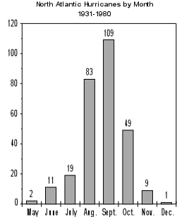
| Again, because a hurricane derives its energy from the warm ocean waters
in the topics and subtropics, hurricanes are more frequent in the late summer months.
Thus, as seen in the graph, hurricanes in the Atlantic ocean are more frequent in
the months of August, September and October. None have been recorded in January
through April.
|
 |
|
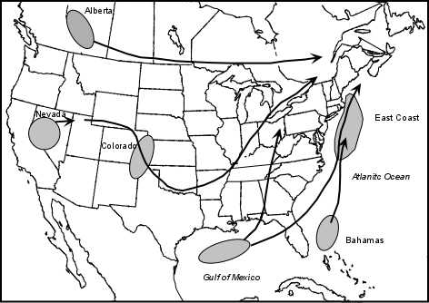
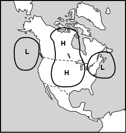
| Changes in Hurricane Tracks and Intensities Because hurricanes are influenced by large-scale air masses, they sometimes move along rather erratic paths. Hurricanes are especially influenced by the strength and direction of upper level winds. As noted above, strong upper level winds create a vertical wind shear that cause the top of the hurricane to be sheared off and result in the loss of strength of the storm. The erratic nature of a hurricane's path often makes it difficult to predict where and when it will make landfall prior to several hours before it actually does make landfall. In the lower latitudes, near the equator, hurricanes generally are pushed by the easterly trade winds and have storm center velocities that are relatively low (8 to 32 km/hr). As they move northward, storm center velocities generally increase to greater than 50 km/hr. This increase in storm center velocity usually results from the interaction of the storm with other air masses. Off the eastern coast of the United States there is an area of semi-permanent high pressure, known as the Bermuda High. Other high pressure centers are continually moving eastward off of North America. If the hurricane encounters a low pressure trough between two high pressure centers, it is steered into the trough and follows it along a northeastward trend, increasing its velocity as it does so. Interaction with the land and other air masses are most responsible for changes in hurricane tracks and intensities. Some examples are shown on the map below. Two of the most erratic hurricane paths recorded are shown by Hurricane Betsy, in 1965 and Hurricane Elena in 1985. |
|
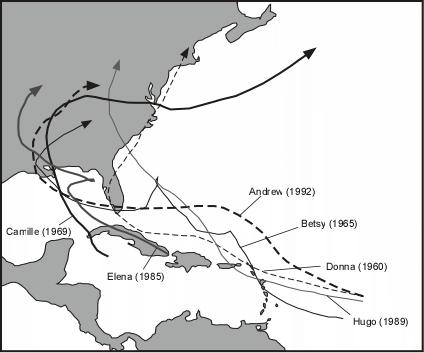 |
In Florida and Louisiana it caused about $7.4 billion (1996 dollars) in damage and
killed 76 people along its track. |
|
|
|
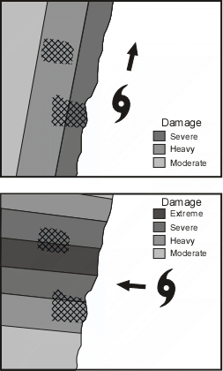
| Angle of Hurricane Approach to Coast The amount of damage that occurs when a hurricane approaches a coast depends on the angle of approach. Two extreme examples illustrate this point. |
|
 |
|
| Storm Surges Heavy winds produced by hurricanes push the ocean in front of them. As this water gets pushed into the shallow zones along the coastline sea level rises. Since the storm surge is driven by the winds, the height of the rise in sea level is related to the velocity of the wind. For a moving storm the greater winds occur on the right side of the storm (in the northern hemisphere). Sea level also rises beneath the eye of the storm due to the low pressure in the eye. But, the surge generated by this low pressure is usually much less than the wind-driven surge. The height of the storm surge depends on wind speed, the shape of the coastline, and variations in the water depth along the coast line. |
|
| Height also depends on tidal cycles. If a storm approaches the coast during high
tide, the storm surge will be higher than if it approaches during low tide. Category
5 tropical cyclones can produce storm surges in excess of 6m (20 feet). The
highest storm surge measured, 12.8 m (42 feet) occurred in 1899 in Australia. |
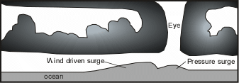 |
| Because the storm surge occurs ahead of the eye of the storm, the surge will reach coastal areas long before the hurricane makes landfall. This is an important point to remember because flooding caused by the surge can destroy roads and bridges making evacuation before the storm impossible. | |
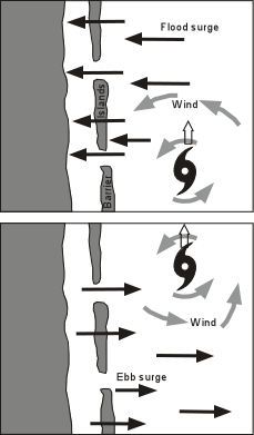
| Since thunderstorms accompany hurricanes, and these storms can strike inland areas
long before the hurricane arrives, water draining from the land in streams and estuaries
may be impeded by the storm surge that has pushed water up the streams and
estuaries. It is also important to remember that water that is pushed onto the land by the approaching storm (the flood surge) will have to drain off after the storm has passed. Furthermore after passage of the storm the winds typically change direction and push the water in the opposite direction. Damage can also be caused by the retreating surge, called the ebb surge. Along coastal areas with barrier islands offshore, the surge may first destroy any bridges leading to the islands, and then cause water to overflow the islands. Barrier islands are not very safe places to be during an approaching hurricane! |
 |
| Hurricane Damage Hurricanes cause damage as a result of the high winds, the storm surge, heavy rain, and tornadoes that are often generated from the thunderstorms as they cross land areas. Strong winds can cause damage to structures, vegetation, and crops, as described in the Saffir-Simpson scale discussed previously. The collapse of structures can cause death. The storm surge and associated flooding, however, is what is most responsible for casualties. Extreme cases of storm surge casualties have occurred as recently as 1970 and 1990 in Bangladesh. As mentioned in a previous lecture, Bangladesh is an area with high population density and with over 30% of the land surface less than 6 m above sea level. In 1970 a cyclone struck Bangladesh during the highest high tides (full moon). The storm surge was 7 m (23 ft.) high and resulted in about 400,000 deaths. Another cyclone in 1990 created a storm surge 6 m high and resulted in 148,000 deaths. The amount of damage caused by a tropical cyclone is directly related to the intensity of the storm, the duration of the storm (related to its storm-center velocity, as discussed above), the angle at which it approaches the land, and the population density along the coastline. The table below shows how damages are expected to increase with increasing tropical storm category. Like the Richter scale for earthquakes, damage does not increase linearly with increasing hurricane category. |
Category Relative Damage
Median Damage (1990 Dollars)
1 1 $24 million 2 4 $218 million 3 40 $1.1 billion 4 120 $2.3 billion 5 240 $6.9 billion
| Predicting Hurricane Frequency and Intensity As discussed above, modern methods of weather forecasting involving satellites, radar, etc. allow accurate tracking of the development and paths of hurricanes. In addition, computer models have been developed by the National Weather Service that enable the prediction of storm surge levels along the U.S. coast, given data on wind velocity, wind distribution, and storm center velocity. These models were accurate to within about 1 foot for the levels of the storm surge that accompanied Hurricane Hugo along the South Carolina coast in 1989. Computer models have also been developed to predict the paths the storms will take and have met with moderate success. Accurate forecasting of storm tracks is more problematical because of the numerous variables involved and the erratic paths hurricanes sometimes take. |
| Some progress has been made in predicting the number and intensity of storms for the
Atlantic Ocean by Dr. William Gray of Colorado State University. He has shown that
there is a correlation between the frequency of intense Atlantic hurricanes with the
amount of rainfall in western Africa in the preceding year. This correlation has allowed
fairly accurate forecasts of the number of storms of a given intensity that will form each
year. The 1997 predictions, however, did not take into account the effects of El
Ni˝o, which reduces the number of hurricanes. Nevertheless, Dr. Gray's predictions are
closely watched, and have been otherwise fairly accurate. Reducing Hurricane
Damage
|
Other Severe Weather Phenomena Nor'easters |
|
| Nor'easters originate in various locations and move across the U.S., converging near the east coast. They are called Nor'easters because the cyclonic circulation causes winds to blow out of the northeast as the storms move up coast. Nor'easters usually have winds less than hurricane strength (<115 km/hr), but they last several days and can create storm surges up to 7 meters high. |
 After Coch (1995) |
| Drought and Famine In contrast to the exceptional weather conditions we have discussed so far, which tend to bring high quantities of rainfall, a drought is a period of time of abnormal dryness in a region. Droughts are slow onset hazards that may lead to secondary effects like famine. |
| In the U.S., droughts are caused when upper level air flow creates a long lasting high pressure ridge over the central U.S. The high pressure causes anticyclonic flow bringing dry air down to the surface. As this air sinks in the high pressure areas it warms and the relative humidity decreases further. Thus the air is so undersaturated with water that it sucks up even more water from the surface. Such persistent high pressure zones block the flow of warm moist air from the Gulf of Mexico, preventing storms that would normally bring rain. Such a condition existed in the central U.S. beginning in 1930, persisting to about 1936. This caused severe dust storms throughout the Midwest, giving the period its name - the great "Dust Bowl". The drought caused massive crop failure, malnutrition, the abandonment of thousands of farms, and large mass-migration of people to California. |
 |
El Ni˝o
The phenomena is manifested by the arrival of warm water off the coast of Peru around Christmas time, and thus is called El Ni˝o (Spanish for the boy child) because it arrives at this time. An El Ni˝o event occurs every 2 to 7 years with various degrees of strength. Some El Ni˝o events are more intense than others, and the condition lasts from 18 to 24 months. The following table lists the years of El Ni˝o events. |
El Ni˝o Years 1902-1903 1905-1906 1911-1912 1914-1915 1918-1919 1923-1924 1925-1926 1930-1931 1932-1933 1939-1940 1941-1942 1951-1952 1953-1954 1957-1958 1965-1966 1969-1970 1972-1973 1976-1977 1982-1983 1986-1987 1991-1992 1994-1995 1997-1998
| "Normal" Conditions - Under "normal" conditions the easterly trade winds, driven by the pressure difference between the eastern Pacific high and the western Pacific low and blowing toward the equator, push warm water toward the equator and across the Pacific Ocean toward Australia and Indonesia. This causes a pool of warm water to form near the equator in the western Pacific. It also causes the thermocline (the boundary between warm waters in the upper layers of the ocean and the cold deep waters below) to move closer to the surface off the coast of South America, bringing nutrient-rich waters to surface by upwelling. Such nutrient-rich waters help sustain large fish populations. The upwelling cold water cools the atmosphere above, and prevents rain clouds from forming off the coast of Peru. |
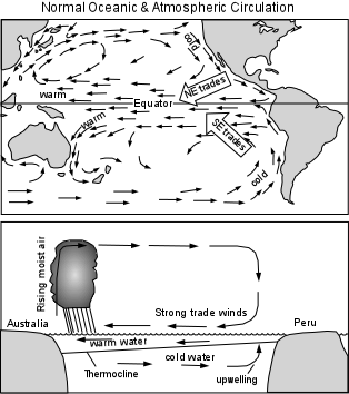 |
| The warm water pushed to the west by the trade winds, heats as it flows along the equator, so that on arrival in the western Pacific heat is added to the overlying atmosphere causing it to rise, form clouds, and produce extensive rainfall. The moisture depleted upper atmosphere then circulates back to east where it descends off the coast of South America contributing to the dry conditions. During periods of exceptionally strong trade winds the upwelling of cold water off the South America cools the water even further creating a condition called La Ni˝a (girl child). |
|
| El Ni˝o Conditions - During El Ni˝o periods there is a
weakening of the easterly trade winds and the warm waters of the western Pacific are
pushed toward the east. This causes the thermocline in the eastern Pacific to sink,
preventing the upwelling of cold waters from below, depleting the waters in nutrients, and
thus leading to starvation of fish populations. As the warm water shifts eastward so
does the development of atmospheric disturbances that lead to upwelling of the atmosphere
to form thunderstorms. Rising bodies of moist air thus occur closer to the coast of
the Americas, leading to increased storminess, not only in South America, but in North
America as well. These low pressure systems that develop in the eastern Pacific can
move over the continent and cause severe weather as noted above. |
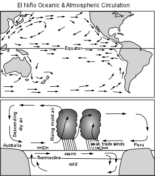 |
| In addition, they create upper level winds that tend to shear the tops off of
developing tropical storms and hurricanes in the Atlantic Ocean and Gulf of Mexico,
leading to a decrease in the number of intense tropical cyclones that develop in these
regions. La Ni˝a conditions have about the opposite effect of El Ni˝o conditions. i.e. better fishing harvests off the west coast of South America, drier conditions in North and South America, more hurricanes in the Atlantic, and wetter conditions in Australia and Indonesia. Over the past 50 years, the oscillation of warm water back and forth across the tropical Pacific Ocean has created El Ni˝o conditions 31% of the time, La Ni˝a conditions 23% of the time, and "normal" conditions 46% of the time. |
| Prediction of El Ni˝o As can be seen from the data presented above, the southern oscillation which creates the El Ni˝o condition has operated throughout the last century. Archeological evidence from South America indicates that the oscillation has been operating for thousands of years. Still, it has only been in recent years that atmospheric and ocean scientists have become aware of the phenomenon, and then only because particularly strong El Ni˝os occurred in the years 1982-83 and 1997-98 causing considerable damage from natural disasters in North America. The frequency of El Ni˝o events and the intensity of the events is not statistically predictable. In other words we do not as yet know when the next El Ni˝o will occur. This is due to the relatively short amount of historical data currently available. Still, the 1997-98 event and its intensity were predictable several months beforehand because measurements of sea surface temperature from satellites and instrument buoys in the Pacific Ocean were able to identify the movement warm surface waters from west to east across the Pacific Ocean. Thus, future El Ni˝o events will likely be predictable several months before they actually develop. This could have important economic consequences. For example, knowing that an El Ni˝o event is coming could result in farmers in normally dry parts of South America preparing the soil for a good crop months in advance because of the expected wetter weather in the months ahead. Fishermen could begin preparing for a poor fishing harvest off the coast of South America. In terms of Natural disasters, Peru was much better prepared for the 1997-98 El Ni˝o and constructed storm drains and stockpiled emergency supplies, probably saving thousands of lives. It is important to remember that because the southern oscillation shifts back and forth, some areas receive beneficial aspects of the phenomenon while other areas receive adverse aspects. For example, even though the 1997-98 El Ni˝o produced many natural disasters in North and South America, the northern part of the U.S. was somewhat warmer during the winter months resulting in the estimated savings of $5 billion in heating costs. |