EENS 3050

Natural Disasters

Tulane University

Prof. Stephen A. Nelson

Homework V: Mass Movement Exercises


  1. The web site at http://landslides.usgs.gov/hazards/nationalmap/ shows the National Landslide Hazards Map, published by the U.S. Geological Survey.   This is a map of the lower 48 states showing areas where there have been a high incidence of landslides, and areas that have a high susceptibility to landslides.  Notice that you can click on various dots on the map and map legend to get an enlargement of various areas or the legend of the map.  On the large map, the areas colored in red are areas where there is a high incidence of landslides (covering greater than 15% of the area).  There are three major zones where high incidence of landslides occur. (1) near the west coast in the states of California, Oregon, and Washington, (2) in the Rocky Mountain states of Colorado, Utah, and Wyoming, and (3) in the Appalachian mountain states of Ohio, Pennsylvania, Virginia, West Virginia, Kentucky, Tennessee, and Georgia.  Surrounding these areas are areas of high to moderate susceptibility to landslides.
    1. For each of these three areas that have high incidence or susceptibility to landslides, what geologic features are present that contribute to the high incidence or susceptibility to landslides?  In answering this question, think about the major factors involved in landslides (the role of gravity, especially slope angle, the role of water, the role of different geological materials like soil and rock, and the presence of processes that trigger landslides (see lecture notes on Slope Stability if you need reminders about these factors).  BE VERY SPECIFIC FOR EACH OF THE 3 AREAS. (6 points)
       
    2. Find as near as possible the area where you live (when not attending Tulane).  What zone do you live in (answer by first stating exactly where you live, then by indicating the color zone on the map and the meaning of the color zone from the map legend)?  If it is a zone with a moderate to high incidence of landslides or a zone with a moderate to high susceptibility to landslides, what features in the area do you think are responsible for the incidence or susceptibility rating?  If it is zone with a low incidence or low susceptibility of landslides, what features or lack of features are responsible for the incidence or susceptibility rating? (2 points)

  1. Since you decided not to take the job in Fargo due to the flood threat, you are back in your house near San Francisco and comfortably settled into your job as an executive with Denyallclaims Insurance Company.  One of your friends is a developer who is planning a resort hotel project in southern California and wants to get a good deal on insurance coverage from Denyallclaims.  His project is on the bluff located just to the northeast of a town called La Conchita, on the coast in Ventura County, California.  You can see an image of the proposed property at the following link: 

    http://www.tulane.edu/~sanelson/geol204/images/LaConchitaIRimage.jpg

    Before agreeing to insure this project, you vaguely recall having heard something about La Conchita in in your natural disasters class.  Because you know that your company will probably take away your job (and house) if they have to pay large claims, you decide to fly down to La Conchita to check it out.  But, since your company does not like to pay travel expenses either, you decide that a better approach would be to use the internet (particularly a U.S. Geological Survey site, but you should also look at several other sites) to check out this property. By doing so, you quickly learn that there have been two events in the last 20 years that have affected the community.


    1. Discuss any disastrous events that have occurred in La Conchita within the last 25 years, including a description of events, any damage that has occurred, and any serious injuries or deaths that have resulted from these events. (2 points)

    2. Were any mitagation measures taken between the two events to prevent further disasters?  If so, what measures were taken and how effective were they? (2 points)

    3. You should be able to find plenty of photos, maps (try Google Maps), and diagrams of the area that includes the area northeast of La Conchita.  From those photos, what is your evaluation of the risk involved in building a resort hotel on the bluff just to the northeast of La Conchita?  Be sure to consider not only the possible damage to the hotel, but possible risk to other properties as well.  (2 points)

    4. Have any lawsuits been filed and decided concerning the most recent event that occurred at La Conchita?   If so, who sued, who was sued, and who won?  (2 points)

  1. Whether or not you currently live in an area prone to landslides, you may in the future.  It would be a good idea to know something about some of the features to look for that might indicate a landslide may occur in the near future, especially if there is any sloping ground around the area.  Find an internet site (hint, the U.S. Geological Survey has a good one) that tells you what features to look for.

    1. Give at least 14 such features that might be noticed before landslides occur. (3 points)

    2. List 3 things you should do if you suspect immediate landslide danger. (2 point) 

  1. At 10:37 AM on March 23, 2014 a hillside on the north bank of the North Fork
    Stillaguamish River, near the town of Oso, Washington collapsed in a large landslide. The landslide, now called the Oso Landslide, was deadliest in U.S. history.  You can view this landslide on Google Maps or Google Earth by searching for the coordinates - 48°16'57"N 121°50'53"W.   Use the internet and other information provided to answer the following questions.

    1. How many people were killed, how many structures were destroyed, and what was the estimated cost of this landslide disaster? (2 points)

    2. For those of you who have Google Earth installed on your computer, you can look at the historical imagery function of Google Earth to see what the landslide area looked like before March 22, 2013. If you don't have Google Earth installed, an image from July 2013 can be downloaded by clicking here and an image from late March 2014 can be downloaded by clicking here.   You can also look at before and after images at - http://www.cnn.com/interactive/2014/03/us/washington-landslide-before-after/?iid=article_sidebar   Using your now extensive experience of looking at satellite images of landslides, what do you see on the pre-landslide Google Earth image that would suggest that a future landslide might occur at this site?  (2 points)?

    3. Breiefly explain what happened during this landslide in 2014 (2 points)

    4. What was the probable trigger for the 2014 landslide? (1 point)

    5. Have any other landslides occurred in this area in the last 100 years?  If so, when and where? (1 point)

    6. Was anything done to mitigate against future landslides at this site?  If so, what measures were taken or considered? (1 point)

    7. See the following - http://www.earthmagazine.org/article/dating-landslides-around-oso-reveals-recurring-patterns - what is the recurrence interval for landslides in this area?  (1 point)

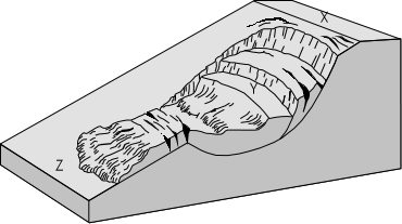
  1. For each of the following drawings, determine (i) What potential mass-movement hazards exist, (ii) why these hazards exist, and (iii) what might be done to mitigate the hazard or remove the danger. Be sure to consider all information available, such as direction of fractures, type of rock or soil, slope angle, and any other features shown on the drawings. (This question will be graded on how well you use the terminology and concepts that we will have discussed in lecture). (2 points each)


  1. Creep.GIF (13440 bytes)


  1. SeaCliff.GIF (11925 bytes)


  1. scarps.GIF (16143 bytes)

    For this one (d) also state which site (X, Y, or Z), if any, would be the best site on which to build your house. (1 point).

Return to EENS 3050 Homepage