EENS 3050

Natural Disasters

Tulane University

Prof. Stephen A. Nelson

Slope Stability, Triggering Events, Mass Movement Hazards


Factors that Influence Slope Stability

Gravity
The main force responsible for mass movement is gravity. Gravity is the force that acts everywhere on the Earth's surface, pulling everything in a direction toward the center of the Earth. On a flat surface the force of gravity acts downward. So long as the material remains on the flat surface it will not move under the force of gravity.

gravflat.GIF (3181 bytes)

Of course if the material forming the flat surface becomes weak or fails, then the unsupported mass will move downward.


On a slope, the force of gravity can be resolved into two components: a component acting perpendicular to the slope and a component acting tangential to the slope.

gravslope.GIF (9669 bytes)
  • The perpendicular component of gravity, gp, helps to hold the object in place on the slope. The tangential component of gravity, gt, causes a shear stress parallel to the slope that pulls the object in the down-slope direction parallel to the slope.

  • On a steeper slope, the shear stress or tangential component of gravity, gt, increases, and the perpendicular component of gravity, gp, decreases.

  • The forces resisting movement down the slope are grouped under the term shear strength which  includes frictional resistance and cohesion among the particles that make up the object.

  • When the sheer stress becomes greater than the combination of forces holding the object on the slope, the object will move down-slope.

  • Alternatively, if the object consists of a collection of materials like soil, clay, sand, etc., if the shear stress becomes greater than the cohesional forces holding the particles together, the particles will separate and move or flow down-slope.

Thus, down-slope movement is favored by steeper slope angles which increase the shear stress, and anything that reduces the shear strength, such as lowering the cohesion among the particles or lowering the frictional resistance.  This is often expressed as the safety factor, Fs, the ratio of shear strength to shear stress.

Fs = Shear Strength/Shear Stress

Shear strength consists of the forces holding the material on the slope and could include friction, and the cohesional forces that hold the rock or soil together.  If the safety factor becomes less than 1.0, slope failure is expected. 


The Role of Water

Although water is not always directly involved as the transporting medium in mass movement processes, it does play an important role.


Water becomes important for several reasons

  1. Addition of water from rainfall or snow melt adds weight to the slope.  Water can seep into the soil or rock and replace the air in the pore space or fractures.  Since water is heavier than air, this increases the weight of the soil.  Weight is force, and force is stress divided by area, so the stress increases and this can lead to slope instability.

  2. Water has the ability to change the angle of repose (the slope angle which is the stable angle for the slope).

    Think about building a sand castle on the beach. If the sand is totally dry, it is impossible to build a pile of sand with a steep face like a castle wall. If the sand is somewhat wet, however, one can build a vertical wall. If the sand is too wet, then it flows like a fluid and cannot remain in position as a wall.
  • Dry unconsolidated grains will form a pile with a slope angle determined by the angle of repose. The angle of repose is the steepest angle at which a pile of unconsolidated grains remains stable, and is controlled by the frictional contact between the grains. In general, for dry materials the angle of repose increases with increasing grain size, but usually lies between about 30 and 45 o.

DrySand.GIF (13428 bytes)

  • Slightly wet unconsolidated materials exhibit a very high angle of repose because surface tension between the water and the solid grains tends to hold the grains in place.

WetSand.GIF (15815 bytes)


  • When the material becomes saturated with water, the angle of repose is reduced to very small values and the material tends to flow like a fluid. This is because the water gets between the grains and eliminates grain to grain frictional contact.


slurry.GIF (14393 bytes)

  1. Water can be adsorbed or absorbed by minerals in the soil.  Adsorption, causes the electronically polar water molecule to attach itself to the surface of the minerals.  Absorption causes the minerals to take the water molecules into their structure.  By adding water in this fashion, the weight of the soil or rock is increased.  Furthermore, if adsorption occurs then the surface frictional contact between mineral grains could be lost resulting in a loss of cohesion, thus reducing the strength of the soil.

    Clays.GIF (15481 bytes)

    In general, wet clays have lower strength than dry clays, and thus adsorption of water leads to reduced strength of clay-rich soils.
  1. Water can dissolve the mineral cements that hold grains together.  If the cement is made of calcite, gypsum, or halite, all of which are very soluble in water, water entering the soil can dissolve this cement and thus reduce the cohesion between the mineral grains.

  2. Liquefaction - As we have already discussed, liquefaction occurs when loose sediment becomes oversaturated with water and individual grains loose grain to grain contact with one another as water gets between them.

This can occur as a result of ground shaking, as we discussed during our exploration of earthquakes, or can occur as water is added as a result of heavy rainfall or melting of ice or snow.  It can also occur gradually by slow infiltration of water into loose sediments and soils.

 
Liquefaction.GIF (20107 bytes)


The amount of water necessary to transform the sediment or soil from a solid mass into a liquid mass varies with the type of material. Clay bearing sediments in general require more water because water is first absorbed onto the clay minerals, making them even more solid-like,  then further water is needed to lift the individual grains away from each other.

  1. Groundwater exists nearly everywhere beneath the surface of the earth.   It is water that fills the pore spaces between grains in rock or soil or fills fractures in the rock. The water table is the surface that separates the saturated zone below, wherein all pore space is filled with water from the unsaturated zone above.   Changes in the level of the water table occur due changes in rainfall. The water table tends to rise during wet seasons when more water infiltrates into the system, and falls during dry seasons when less water infiltrates.  Such changes in the level of the water table can have effects on the factors (1 through 5) discussed above.


  2. Another aspect of water that affects slope stability is fluid pressure. As soil and rock get buried deeper in the earth, the grains can rearrange themselves to form a more compact structure, but the pore water is constrained to occupy the same space.  This can increase the fluid pressure to a point where the water ends up supporting the weight of the overlying rock mass.  When this occurs, friction is reduced, and thus the shear strength holding the material on the slope is also reduced, resulting in slope failure.

Troublesome Earth Materials

  • Expansive and Hydrocompacting Soils - These are soils that contain a high proportion of a type of clay mineral called smectites or montmorillinites. Such clay minerals expand when they become wet as water enters the crystal structure and increases the volume of the mineral.  When such clays dry out, the loss of water causes the volume to decrease and the clays to shrink or compact (This process is referred to as hydrocompaction).    

Clays.GIF (15481 bytes)

Another material that shows similar swelling and compaction as a result of addition or removal of water is peat.  Peat is organic-rich material accumulated in the bottoms of swamps as decaying vegetable matter. 

  • Sensitive Soils - In some soils the clay minerals are arranged in random fashion, with much pore space between the individual grains. This is often referred to as a "house of cards" structure.  Often the grains are held in this position by salts (such as gypsum, calcite, or halite) precipitated in the pore space that "glue" the particles together.

As water infiltrates into the pore spaces, as discussed above, it can both be absorbed onto the clay minerals, and can dissolve away the salts holding the "house of cards" together.

HouseCards.GIF (29470 bytes)

Compaction of the soil or shaking of the soil can thus cause a rapid change in the structure of the material.  The clay minerals will then line up with one another and the open space will be reduced. 


    But this may cause a loss in shear strength of the soil and result in slippage down slope or liquefaction.  This is referred to as remolding.   Clays that are subject to remolding are called quick clays.

  • Some clays, called  thixotropic clays, when left undisturbed can strengthen, but when disturbed they loose their shear strength. Thus, small earthquakes or vibrations caused by humans or the wind can suddenly cause a loss of strength in such materials.

Weak Materials and Structures

  • Bedding Planes - These are basically planar layers of rocks upon which original deposition occurred.  Since they are planar and since they may have a dip down-slope, they can form surfaces upon which sliding occurs, particularly if water can enter along the bedding plane to reduce cohesion. In the diagram below, note how the slope above the road on the left is inherently less stable than the slope above the road on the right.


Weak Layers - Some rocks are stronger than others.  In particular, clay minerals generally tend to have a low shear strength.  If a weak rock or soil occurs between stronger rocks or soils, the weak layer will be the most likely place for failure to occur, especially if the layer dips in a down-slope direction as in the illustration above. Similarly, loose unconsolidated sand has no cohesive strength.  A layer of such sand then becomes a weak layer in the slope.

  • Joints & Fractures - Joints are regularly spaced fractures or cracks  in rocks that show no offset across the fracture (fractures that show an offset are called faults).

    • Joints form as a result of expansion due to cooling, or relief of pressure as overlying rocks are removed by erosion.

    • Joints form free space in rock by which water, animals, or plants can enter to reduce the cohesion of the rock.

If the joints are parallel to the slope they may become a sliding surface.   Combined with joints running perpendicular to the slope (as seen in the sandstone body in the illustration above), the joint pattern results in fractures along which blocks can become loosened to slide down-slope.

  • Foliation Planes - During metamorphism of rock, differential stress causes sheet silicate minerals, like clay minerals, biotite, and muscovite, to grow with their sheets parallel to one one another,  This results in the rock having a foliation or schistosity   Because the sheet silicates can break easily parallel to their sheet structure, the foliation or schistosity may become a slip surface, particularly if it it dips in the down-slope direction.


Triggering Events

A mass movement event can occur any time a slope becomes unstable. Sometimes, as in the case of creep or solifluction, the slope is unstable all of the time and the process is continuous. But other times, triggering events can occur that cause a sudden instability to occur. Here we discuss major triggering events, but it should be noted that it if a slope is very close to instability, only a minor event may be necessary to cause a failure and disaster.  This may be something as simple as an ant removing the single grain of sand that holds the slope in place.


  • Shocks - A sudden shock, such as an earthquake may trigger slope instability. Minor shocks like heavy trucks rambling down the road, trees blowing in the wind, or human made explosions can also trigger mass movement events.

    Examples:

Turnagain Heights Alaska, 1964
During the Good Friday earthquake on March 27, 1964, a suburb of Anchorage, Alaska, known as Turnagain Heights broke into a series of slump blocks that slid toward the ocean. This area was built on sands and gravels overlying marine clay.The upper clay layers were relatively stiff, but the lower layers consisted of a sensitive clay, as discussed above.  The slide moved about 610 m toward the ocean, breaking up into a series of blocks.

It began at the sea cliffs on the ocean after about 1.5 minutes of shaking caused by the earthquake, when the lower clay layer became liquefied.  As the slide moved into the ocean, clays were extruded from the toe of the slide.  The blocks rotating near the front of the slide, eventually sealed off the sensitive clay layer  preventing further extrusion. 

Turnagain.GIF (11734 bytes)

This led to pull-apart basins being formed near the rear of the slide and the oozing upward of the sensitive clays into the space created by the extension.  75 homes on the top of the slide were destroyed by the movement of the mass of material toward the ocean.


Nevados de Huascarán, Peru, 1962 and 1970.

    Nevados de Huascarán is a high peak in the Peruvian Andes Mountains.  The peak consists of granite with nearly vertical joints (fractures) covered by glacial ice. On January 10, 1962 a huge slab of rock and glacial ice suddenly fell, with no apparent triggering mechanism.  This initiated a debris flow that moved rapidly into the valley below and killed 4,000 people in the town of Ranrahirca, but stopped when it reached the hill called Cerro de Aira, and did not reach the larger population center of Yungay.   


    On May 31, 1970 a  magnitude 7.7 earthquake occurred on the subduction zone 135 km away from the Nevados de Huascarán. 

NHuascaran.GIF (11848 bytes)


Shaking in the area lasted for 45 seconds, and during this shaking another large block of the Nevados de Huascarán between 5,500 and 6,400 meters elevation fell from the peak.


    This time it became a debris avalanche sliding across the snow covered glacier and  moving down slope at velocities up to 335 km/hr. The avalanche then hit a small hill composed of glacially deposited sediment and was launched into the air as an airborne debris avalanche.  From this airborne debris, blocks the size of large houses fell on real houses for another 4 km.  The mass then recombined in the vicinity of Cerro de Aira and continued flowing as a debris flow, burying the town of Yungay and its 18,000 residents.  


The debris flow reached the valley of the Rio Santa and climbed up the valley walls killing another 600 people on the opposite side of the river.  Since then, the valley has been repopulated, and currently large cracks are seen on the remains of the glacier that still covers the upper slopes of Nevados de Huascarán.

  • Slope Modification - Modification of a slope either by humans or by natural causes can result in changing the slope angle so that it is no longer at the angle of repose. A mass movement event can then restore the slope to its angle of repose.
SlopeMod.GIF (10091 bytes)
  • Undercutting - streams eroding their banks or surf action along a coast can undercut a slope making it unstable.
Undercut.GIF (9315 bytes)

Example:  Elm Switzerland, 1881

In 1870s there was a large demand for slate to make blackboards throughout Europe.   To meet this demand, miners near Elm, Switzerland began digging a slate quarry at the base of a steep cliff.  Slate is a metamorphic rock with an excellent planar foliation that breaks smoothly along the foliation planes.   By 1876 a "v" shaped fissure formed above the cliff, about 360 meters above the quarry.  By September 1881, the quarry had been excavated to where it was 180 m long and 60 m into the hill below the cliff, and the "v" shaped fissure had opened to 30 m wide. Falling rocks were frequent in the quarry and their were almost continuous loud noises heard coming from the overhang above the quarry. 

Realizing that the slope had become unstable, the miners stopped working, thinking that the rock mass above the quarry would probably fall down.

Elm.GIF (17539 bytes)

On September 11, 1881 the 10 million m3 mass of rock above the quarry suddenly fell. But, it did not stop when it hit the quarry floor. Instead, it broke into pieces and rebounded into the air. Residents in Untertal, on the opposite side of the valley from the slide, saw the mass of rebounded rock coming at the them and ran uphill. But the mass of rock continued up the walls of the valley and buried them. The avalanche then turned and ran an additional 2,230 m as a dry avalanche traveling at 180 km/hr burying the village of Elm.  The avalanche killed 115 people.

  • Changes in Hydrologic Characteristics - heavy rains can saturate regolith reducing grain to grain contact and reducing the angle of repose, thus triggering a mass movement event. Heavy rains can also saturate rock and increase its weight.  Changes in the groundwater system can increase or decrease fluid pressure in rock and also trigger mass movement events.

Example: Vaiont Reservoir, Italy, 1963

In 1960 a dam was built across the Vaiont Valley in northeastern Italy near the border with Austria and Slovenia. The valley runs along the bottom of a geologic structure called a syncline, wherein rocks have been folded downward and dip into the valley from both sides (see cross section below).

The rocks are mostly limestones, but some are intricately interbedded with sands and clays.  These sand and clay layers form bedding planes that parallel the syncline structure, dipping steeply into the valley from both sides.

Viaont.GIF (19481 bytes)

Fracture systems in the rocks run parallel to the bedding planes and perpendicular to bedding planes.  The latter fractures had formed as a result of glacial erosion which had relieved pressure on the rocks that had formed deeper in the Earth. 

VaiontX_sect.GIF (16773 bytes)

Some of the limestone units have caverns that have been dissolved in the rock due to chemical weathering by groundwater. Furthermore, the dam site was built near an old fault system. During August and September, 1963, heavy rains drenched the area, rasing the water table and adding weight to the rocks above the dam. On October 9, 1963 at 10:41 P.M. the south wall of the valley failed and slid into the reservoir behind the dam. The slide mass was 1.8 km long and 1.6 km wide with a volume of 240 million m3. As the slide moved into the reservoir it displaced the water, forcing it 240 meters above the dam and into the village of Casso on the northern side of the valley. Subsequent waves swept up to 100 meters above the dam. Although the dam did not fail, the water rushing over the dam swept into the villages of Longorone and  T. Vaiont, killing 2,000 people. Waves also swept up the reservoir where they first bounced off the northern shore, then back toward the Pineda Peninsula, and then back up the valley slamming into San Martino and killing another 1000 people. The debris slide had moved along the clay layers that parallel the bedding planes in the northern wall of the valley. A combination of factors was responsible for the slide. First filling of the reservoir had increased fluid pressure in the pore spaces and fractures of the rock. Second, the heavy rains had also increased fluid pressure and also increased the weight of the rock above the slide surface. After the slide event, parts of the reservoir were filled up to 250 m above the former water level, and even though the dam did not fail, it became totally useless.  This event is often referred to as the world's worst dam disaster.

Example: Portuguese Bend, California, 1956
Portuguese Bend lies on the Palos Verdes Peninsula just to the south of Los Angeles, California, but still within Los Angeles County.

In this area the rocks have been folded into a synclinal structure with rock layers dipping gently toward the Pacific Ocean.

PortBend2.GIF (17444 bytes)

Rocks near the surface consist of volcanic ash that has been altered by chemical weathering to an expanding type clay called bentonite. Below these altered ash layers are shales that are interbedded with other thin volcanic ash layers that have been similarly altered to bentonite clay.  The area had the appearance of an earth flow, with a very hummocky topography with many enclosed basins filled with lakes.  Prior to the 1950s the area had been used for farming. In the 1950s demand for ocean views led to the development of the area as an upscale suburb. But, no sewer system was available, so wastes were put into the ground via septic tanks. In 1956 the area began moving down slope toward the ocean. Rates of movement were fastest several months after the end of the winter rainy season and slowest during the summer dry season.  In the next three years the earthflow moved as much as 20 meters, but in the processes the expensive homes built on the flow became uninhabitable.  Movement was caused by a combination of wave erosion along the coast removing some the mass resisting flow, added water due to the disposal of wastes, watering of lawns, and rainfall causing the bentonite clays to expand and weaken, and by the added weight of development on top of the flow.  Property owners looked desperately for someone to sue, and eventually won a suit against the county of Los Angeles who had added fill dirt to build a road into the development (note that since the property owners could not sue themselves, nor could they sue the clay layers responsible for the movement they found the only agency with deep pockets that was available).

  • Volcanic Eruptions - produce shocks like explosions and earthquakes. They can also cause snow to melt or empty crater lakes, rapidly releasing large amounts of water that can be mixed with regolith to reduce grain to grain contact and result in debris flows, mudflows, and landslides.

Examples - We have previously discussed the mudflows and debris avalanche produced by the 1980 eruption of Mount St. Helens, and the devastating mudflows that killed 23,000 people in Armero that resulted from an eruption of Nevado del Ruiz volcano in Columbia.  

StHelensMap.GIF (29525 bytes)

NRuiz.GIF (22507 bytes)

  • Changes in Slope Strength. Anything that acts to suddenly or gradualy change the slope strength can also be a triggering mechanism.

    For example, Weathering creates weaker material, and thus leads to slope failure.

    Vegetation, holds soil in place and slows the influx of water. Trees put down roots that hold the ground together and strengthen the slope.
    Removal of tress and vegetation either by humans or by a forest fire, often results in slope failures in the next rainy season.


Assessing and Mitigating Mass Movement Hazards

As we have seen mass movement vents can be extremely hazardous and result in extensive loss of life and property.  But, in most cases, areas that are prone to such hazards can be recognized with some geologic knowledge, slopes can be stabilized or avoided, and warning systems can be put in place that can minimize such hazards.

Hazard Assessment

If we look at the case histories of mass movement disasters discussed above, in all cases looking at the event in hindsight shows us that conditions were present that should have told us that a hazardous condition existed prior to the event. 

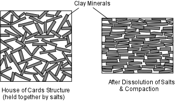
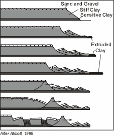
  • Exploration could have revealed the sensitive clays beneath Turnagain Heights, located in known earthquake prone area. The area is now a park.
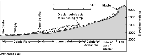
  • The area beneath the slopes of Nevados de Huascarán was littered with debris from prior landslide events, and even thought the first event in 1962 was not caused by an earthquake, it should have been known that the area was susceptible to such a hazard.  The 1962 event should have provided fair warning to inhabitants of the area and the death and destruction caused by the 1970 event should have been avoided.
     
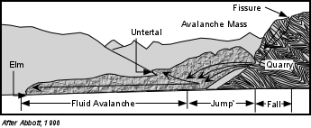
  • Miners in Elm, Switzerland, certainly realized that undercutting of the mountain could cause the mountain to fail, but did not consider the more widespread effect of the avalanche. 
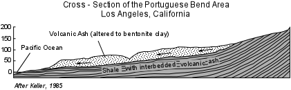
  • In the Portuguese Bend area, planners should have realized that the slope was an earthflow, fine for farming, but not a very desirable place to construct houses of any sort. 
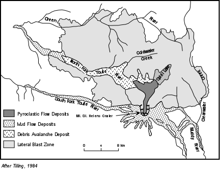
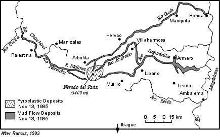
  • In both of the volcanic mudflow cases, the hazards were known before the event.  In the Mount St. Helens case, hazards assessments were available and plans were in effect to minimize further damage once the event occurred.  In the case of Armero, warnings were given, but ignored.  The town was built on mudflow deposits from prior mudflow events.

Because there is usually evidence in the form of distinctive deposits and geologic structures left by recent mass movement events, it is possible, if resources are available, to construct maps of all areas prone to possible mass movement hazards.  See the USGS Landslide Hazards map of the U. S. - http://landslides.usgs.gov/learning/nationalmap/. More detailed state and local maps can be found and most are available on the internet.

Planners can use such hazards maps to make decisions about land use policies in such areas or, as will be discussed below, steps can be taken to stabilize slopes to attempt to prevent a disaster. 

Prediction

Short-term prediction of mass movement events is somewhat more problematical.  For earthquake triggered events, the same problems that are inherent in earthquake prediction are present. Slope destabilization and undercutting triggered events require the constant attention of those undertaking or observing the slopes, many of whom are not educated in the problems inherent in such processes. Mass movement hazards from volcanic eruptions can be predicted with the same degree of certainty that volcanic eruptions can be predicted, but again, the threat has to be realized and warnings need to be heeded.  Hydrologic conditions such as heavy precipitation can be forecast with some certainty, and warnings can be issued to areas that might be susceptible to mass movement processes caused by such conditions. Still, it is difficult of know exactly which hill slope of the millions that exist will be vulnerable to an event triggered by heavy rainfall.
 

Some warning signs can be recognized individual by observations of things around you:

  • Springs, seeps, or saturated ground in areas that have not typically been wet before.
  • New cracks or unusual bulges in the ground, street pavements or sidewalks.
  • Soil moving away from foundations.
  • Ancillary structures such as decks and patios tilting and/or moving relative to the main house.
  • Tilting or cracking of concrete floors and foundations.
  • Broken water lines and other underground utilities.
  • Leaning telephone poles, trees, retaining walls or fences
  • Offset fence lines.
  • Sunken or down-dropped road beds.
  • Rapid increase in creek water levels, possibly accompanied by increased turbidity (soil content).
  • Sudden decrease in creek water levels though rain is still falling or just recently stopped.
  • Sticking doors and windows, and visible open spaces indicating jambs and frames out of plumb.
  • A faint rumbling sound that increases in volume is noticeable as the landslide nears.
  • Unusual sounds, such as trees cracking or boulders knocking together, might indicate moving debris. (from USGS Landslide Hazards - http://landslides.usgs.gov/learning/prepare/)


Prevention and Mitigation


All slopes are susceptible to mass movement hazards if a triggering event occurs.  Thus, all slopes should be assessed for potential mass movement hazards. Mass movement events can sometimes be avoided by employing engineering techniques to make the slope more stable. Among them are:

  • Steep slopes can be covered or sprayed with concrete covered with a wire mesh to prevent rock falls.
  • Retaining walls could be built to stabilize a slope. 

  • If the slope is made of highly fractured rock, rock bolts may be emplaced to hold the slope together and prevent failure.
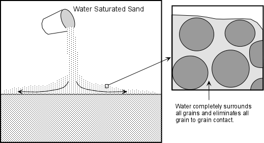
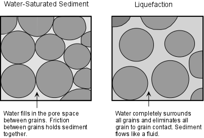
  • Drainage pipes could be inserted into the slope to more easily allow water to get out and avoid increases in fluid pressure, the possibility of liquefaction, or increased weight due to the addition of water.  
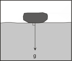
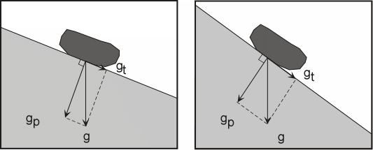
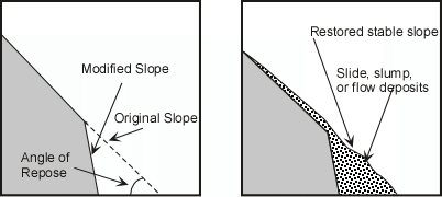
  • Oversteepened slopes could be graded or terraced to reduce the slope to the natural angle of repose.
  • In mountain valleys subject to mudflows, plans could be made to rapidly lower levels of water in human-made reservoirs to catch and trap the mudflows.
  • Some slopes, however, cannot be stabilized.  In these cases, humans should avoid these areas or use them for purposes that will not increase susceptibility of lives or property to mass movement hazards.


Examples of questions on this material that could be asked on an exam

  1. What is the main force responsible for mass movement processes?  How is this force affected by slope angle?

  2. What is the factor of safety and how does it apply to slope stability?

  3. In what ways does water added to a slope affect its stability?

  4. Define the following (a) angle of repose, (b) sensitive soils, (c) hydrocompacting clays, (d) groundwater, (e) quick clays

  5. What kinds of rock structures can reduce the stability of slopes?

  6. What are the major triggering events for mass movement processes?

  7. Is it possible to determine whether or not a slope has stability problems?  If so, how is this done?

  8. What kinds of things can be done to mitigate against mass movement hazards?

References 

Return to EENS 3050 Homepage