Critical Events in New Orleans’ Hurricane History
-
Since the year 1759, 176 hurricanes have struck the Louisiana Coast
-
Frequency is about two hurricanes every three years
-
38 hurricanes have caused significant flooding in New Orleans
-
Hurricane Flooding frequency is about once every 6.5 years.
Significant Hurricane Flooding Events
First hurricane in 1722 - nearly wiped out New Orleans
Other Hurricanes in 1778, 1779, 1790, & 1794 destroyed buildings and sunk ships in the Mississippi River
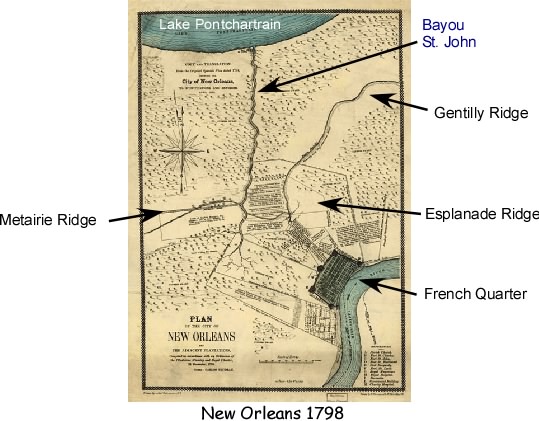
Aug. 9, 1812 “Great Louisiana Hurricane” flooded areas north of city along Lake Pontchartrain. Populated part of New Orleans was protected by the Metairie/Gentilly Ridges
Aug. 16,1831 “Great Barbados Hurricane - Mississippi River levee broke and flooded French Quarter
Although not related to a Hurricane, a Levee Breach in 1849 on the Mississippi River upstream at the Suave Plantation caused water to flow into New Orleans south of the Metairie Ridge causing serious flooding.
1860 - Three Hurricanes struck New Orleans area. One on October 2, caused storm surge in Lake to destroy lake front villages and flood areas north of French Quarter. Again the populated part of the region was somewhat protected from storm surge from Lake Pontchartrain by the Metairie/Gentilly Ridges
1871 - 3 hurricanes create storm surge in Lake that causes localized flooding in New Orleans. City Surveyor W. H. Bell warns of storms moving up drainage canals - suggests moving pumps to lakefront.
1915 Hurricane floods city through drainage canals. 275 deaths
Sept. 19, 1947 Hurricane floods part of city along Industrial Canal and drainage canals. 51 deaths
Sept. 9, 1965 Hurricane Betsy floods on both sides of Industrial Canal. Storm surge entered from Lake Borgne through the recently completed Mississippi River-Gulf Outlet (MR-GO). Hurricane Protection System authorized by Congress shortly thereafter.
Aug. 17, 1969 Hurricane Camille (Cat. 5) hits Mississippi Coast, New Orleans spared from flooding
Sept. 26-28, 1998 Hurricane Georges approaches New Orleans - first time evacuation of city is called for.
Sept. 14-15, 2004 Hurricane Ivan approaches New Orleans, - second evacuation - first time for Contraflow
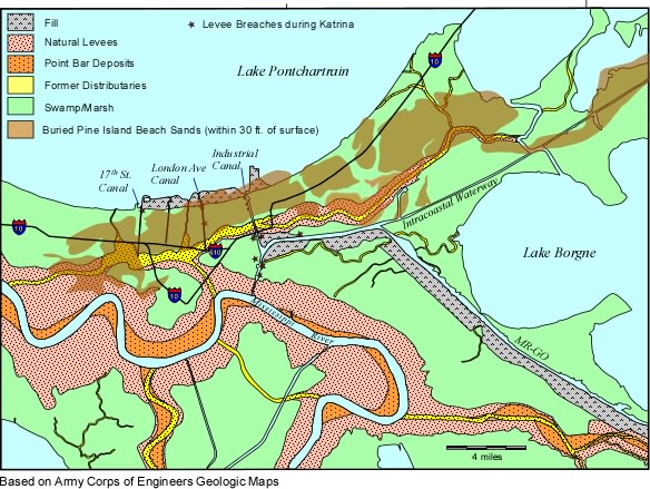
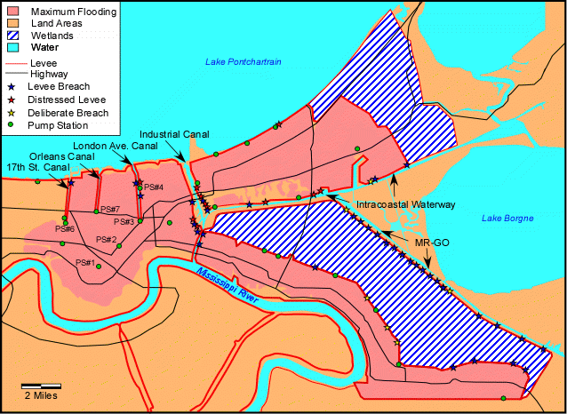
August 29, 2005 - Hurricane Katrina passes to the east of New Orleans (See Figure 8).
-
Creates 28 foot high storm surge on Mississippi Gulf Coast
-
18 foot high storm surge in Lake Borgne flooding nearly all of the populated portion of St. Bernard Parish.
-
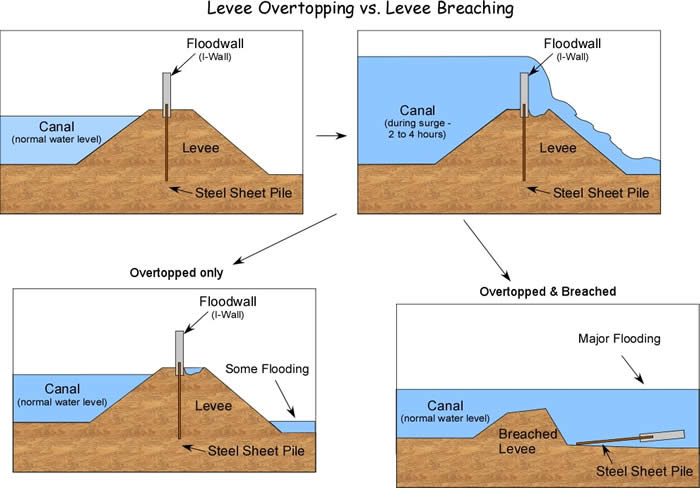
15 foot storm entering the Industrial Canal through the MR-GO, Intracoastal waterway, and Lake Pontchartrain overtops floodwalls, and breaches levees on floodwalls on both sides of the Industrial Canal.
-
11 foot storm surge in Lake Pontchartrain enters 17th St. and London Avenue drainage canals. Canal floodwalls are not overtopped, but floodwalls/levees fail at two locations on the London Ave. Canal and one location on the 17th St. Canal.
-
All levee breaches were on human made navigation or drainage canals and all were levees and floodwalls that had been built by the U.S. Army Corps of Engineers, some as recently as the mid- 1990s
-
Floods over 80% of the city and results in over 1500 deaths.
|
The Hurricane Protection System
(Pre-Katrina)
- Hurricane Betsy in 1965 flooded portions of eastern New Orleans, the Upper Ninth Ward, Lower Ninth Ward, and Gentilly.
- In response, Congress authorized the Lake Pontchartrain and Vicinity, Louisiana Hurricane Protection Project - authorized by Congress in the Flood Control Act of 1965.
- Expected to take 13 years to complete and cost $85 million.
- Designed to protect the New Orleans region from a fast moving Category 3 Storm that would be expected to strike once every 200 to 300 years. Such a storm was designated as the "Standard Project Hurricane".
- Costs were shared - 70% Federal, 30% Local (taxes collected by Levee Districts)
- By 1982, the estimated cost had grown to $924 million
- In 2005 (before Katrina) the expected completion date was projected to be 2017.
Two plans were proposed by the Army Corps of Engineers:
The Barrier Plan
- In the 1970s the Corps proposed building barriers and closeable navigation gates across the 2 inlets into Lake Pontchartrain to prevent hurricane storm surge from Lake Borgne and the Gulf of Mexico from entering the Lake.
- An organization called Save Our Wetlands, filed a lawsuit objecting to the 4 page Environmental Impact Statement (EIS) presented by the Corps, and Judge Charles Schwartz in 1977 ruled that the EIS was inadequate, ruling that the Corps must return with a better EIS (Schwartz, 1977).
- In 1980, the Corps, rather than issue an acceptable EIS, decided against the construction of the barriers and gates.
High Level Plan
- In the 1980s the Corps proposed building levees and floodwalls to a height necessary to keep storm surge from the Lake Pontchartrain and Lake Borgne from entering the city.
- For the three drainage canals, the Corps propsed two plans. One involved putting moveable gates at the Lake ends of the drainage canals (London Avenue, Orleans, and 17th St.). Alternatively they proposed to raise the height of the levees on the canals. The latter was called the Parallel Plan. The Corps stated that it believed either plan would be equally effective.
- The Sewerage & Water Board and Orleans Levee Board objected to putting gates at the end of the canals because the Corps refused to consider inclusion of pumping stations at the gates that would pump rainwater out of the city into the Lake when the gates were closed during a hurricane.
- For the 17th Street Canal, the Corps had no stated prefence because the cost of the gates was roughly the same as the Parallel Plan. The Corps approved raising the height of the levees along the canal because local officials preferred this option.
- For the London Avenue and Orleans Canals, the Corps preferred the gates plan because it was significantly cheaper than the Parallel Plan (three times less for London Avenue and five times less for Orleans).
- The Sewerage and Water Board and Levee Board successfully lobbied Congress for more money for the Parallel Plan. The Corps was ordered to raise the levees and floodwalls on the canals and not build the gates, through passage of the Water Resources Development Act of 1990 (passed in 1992).
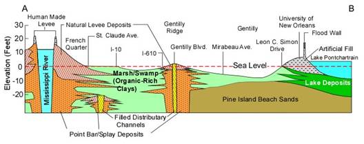
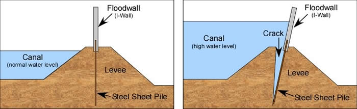
- A levee is a mound of dirt piled up to prevent the inflow of water. Raising the height of a levee also requires widening the levee because dirt can’t hold up to steep slopes.
In an urban environment like New Orleans, widening a levee would require buyouts of property along the levee. This would have been quite expensive.
- Instead, concrete floodwalls were proposed and built since a floodwall can be quite steep and still provide a higher level of protection.
- Two types of floodwalls were used in the New Orleans hurricane protection system (Figure 9)
- I-walls were the most commonly used type of floodwall in the New Orleans flood protection system.
- T-walls offer more resistance to failure, but are more expensive.
|
Why New Orleans is Vulnerable To Hurricanes
Natural Causes
-
Location near Gulf of Mexico
-
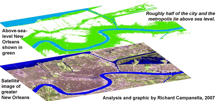
Low elevation (near sea-level)
-
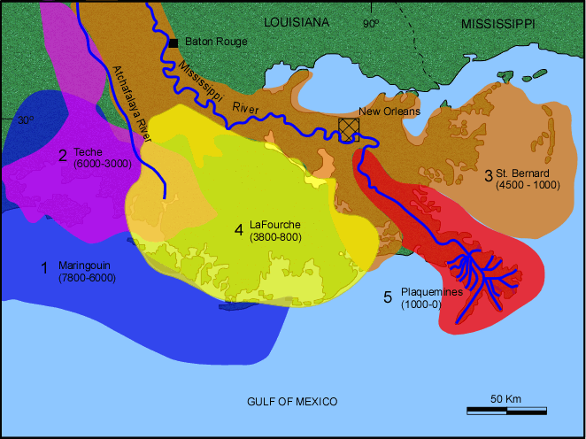
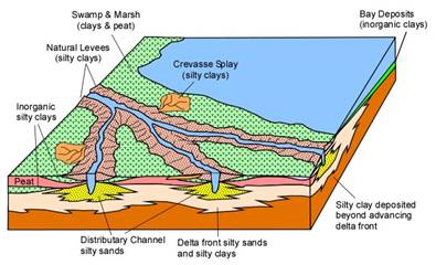
Subsidence - caused by compaction of river deposited sediments
-
Erosion of inactive delta lobe
-
Sea-level rise due to global warming
Human-Related Causes
-
Levees on River prevent flooding, but deprive floodplain of sediment which would normally compensate for natural compaction
Levees on River prevent flooding, but deprive floodplain of sediment which would normally compensate for natural compaction.
-
Coastal Erosion accelerated by human changes to system. The coastline of Louisiana is eroding at an incredible rate, estimated at 25 square miles per year. ( 1 football field of area every 45 minutes). Causes of Coastal Erosion, include the natural processes listed above, as well as the following:
- Navigation and Exploration Canals. During Katrina, all levee/ floodwall breaches occurred on human made navigation and drainage canals that bring water into the heart of the city (See Figure 8).
- Over the last 100 years, hundreds of miles of exploration and navigation canals have been cut through south Louisiana wetlands. This allows salt water to get into the fresh water swamps and marshes, killing the fresh-water vegetation which holds soil in place. Storms and boat traffic can then easily erode the soil.
- Petroleum Extraction - When oil and natural gas are extracted from the subsurface, sediment that once held the oil in the pore spaces, compacts, resulting in subsidence.
- Invasive Species - Nutria are beaver-like animals that were imported from South America in the early 1900s to expand the fur trade. Nutria eat marsh grass and their roots. Without these grasses, storms erode the soil and turn land into water.
- Increased Population - Puts more people and infrastructure at risk
- Population expanding into lower lying areas - When swamps are pumped out to make dry land, the groundwater table is also lowered. Without the groundwater in the pore spaces between sediment grains, the grains compact and cause subsidence. When New Orleans was founded in 1718, none of the current city was below sea-level. Expansion into the swampy areas north of the original city has resulted in as much as 8 feet of subsidence since 1895.
- Inadequate, poorly designed, & incomplete hurricane protection system - as discussed above.
.
Over the next few weeks we will further explore the problems that occurred during Katrina and explore what is being done to reduce the risk and vulnerability.
|
Appendix
Time Line of Important Events Leading up to Hurricane Katrina*
|
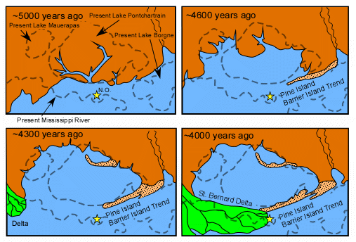
| 5000–4500 BP |
Deposition of Pine Island Barrier Island/Beach Sands |
| 4500–1000 BP |
Deposition of St. Bernard Delta Lobe & formation of Metairie/Gentilly/Esplanade Distributary channels
|
| ~1000 BP |
Current Mississippi River course established |
| 1718 |
Founding of New Orleans |
| 1722 |
Hurricane destroys New Orleans |
| Aug. 9, 1812 |
Great Louisiana Hurricane, struck - flooded areas north of city along Lake Pontchartrain |
| 1821 |
Easterly winds forced water from Lake Pontchartrain up Bayou St. John to flood northern edge of city. |
| Aug. 16,1831 |
“Great Barbados Hurricane” Mississippi River levee broke and flooded French Quarter. |
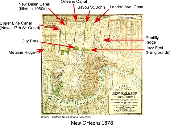
| 1833-34 |
Orleans Canal mostly excavated |
| 1854-58 |
Upperline Canal (17th St. Canal) excavated |
| 1860 |
3 Hurricanes struck New Orleans area. One on October 2, caused storm surge in Lake to destroy lake front villages and flood areas north of French Quarter. |
| 1860s |
Lower London Avenue Canal excavated |
| 1871 |
3 hurricanes create storm surge in Lake that causes localized flooding in New Orleans |
| 1871 |
City Surveyor W. H. Bell warns of storms moving up drainage canals – suggests moving pumps to lakefront. |
| 1873-1878 |
Upper London Avenue Canal excavated |
| 1895? |
Lake Pontchartrain hurricane protection levee (6 ft. above lake level) |
| 1915 |
Hurricane floods city through drainage canals. 275 deaths |
| 1915 |
Baldwin Wood invents high capacity screw pump - allows swamps to be drained for habitation. |
| 1923 |
Industrial Canal completed |
| 1940s |
Inner Coastal Waterway completed |
| Sept. 19, 1947 |
Hurricane floods part of city along Industrial Canal and drainage canals. 51 deaths |
| 1960 |
Corps proposes plan for movable gates at the Lake end of drainage canals |
| 1961 |
Corps proposal for gates at Rigolets and Chef Menteur Pass the “Barrier Plan” |
| 1964 |
MR-GO completed |
| Sept. 9, 1965 |
Hurricane Betsy causes flooding on both sides of Industrial Canal |
| 1965 |
Lake Pontchartrain and Vicinity Hurricane Protection Plan authorized by Congress |
| Aug. 17, 1969 |
Hurricane Camille (Cat. 5) hits Mississippi Coast, New Orleans spared from flooding |
| 1970s |
Floodwall built on Industrial Canal |
| 1977 |
Courts rule against “Barrier Plan”, Corps adopts “High Level Plan” |
| 1984 |
Corps modifies Lake Pontchartrain & Vicinity plan to include floodgates at mouths of canals |
| 1992 |
Water Resources Development Act gives Corps responsibility for hurricane protection on Canals (previously the responsibility of the Orleans Levee district) after Levee District lobbyists successfully have language inserted into the bill. |
| 1993-1999 |
Floodwalls built on drainage canals, but bridges still in progress in 2005. |
| Sept. 27-28. 1998 |
hurricane Georges approaches New Orleans – first time evacuation of city is called for. |
| Sept. 10-11, 2004 |
Hurricane Ivan approaches New Orleans, - second evacuation – first time for Contraflow |
| Aug. 29 2005 |
Hurricane Katrina |
| Dec., 2005 |
Funding for gates at mouths of canals |
| August 2006 |
Completion of gates,
|
Sept. 1, 2008 |
Hurricane Gustav strikes, city evacuated, floodwalls on Industrial Canal overtopped. |