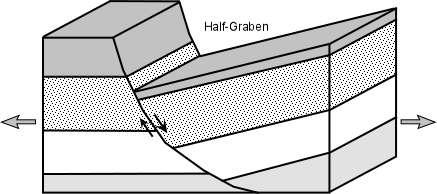
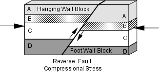
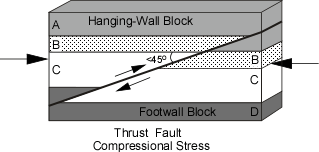
EENS 1110

Physical Geology
 
Tulane University
Prof. Stephen A. Nelson

Deformation of Rock


Mount Everest is the highest peak on Earth at 29,028 feet above sea level.

The rock at the top of the peak is a marine limestone, deposited on the sea floor about 450 million years ago!  This is an amazing fact that begs the question - how did that rock get there?  In this discussion we will try to answer that question.  The topics we will cover include:

  • Review of Stress and Strain
  • Brittle Deformation – Faults and Joints
  • Ductile deformation – Folds
  • Mountain Building Processes

Stress and Strain

We start our discussion with a brief review of the concepts of stress and strain.   Recall that stress is a force acting on a material that produces a strain.  Stress is a force applied over an area and therefore has units of Force/area (like lb/in 2 ). Pressure is a stress where the forces act equally from all directions. 

If stress is not equal from all directions then we say that the stress is a differential stress. Three kinds of differential stress occur.
  1. Tensional stress (or extensional stress), which stretches rock;

  2. Compressional stress, which squeezes rock; and

  3. Shear stress, which result in slippage and translation.
When rocks deform they are said to strain. A strain is a change in size, shape, or volume of a material. We here modify that definition somewhat to say that a strain also includes any kind of movement of the material, including translation and tilting.

Stages of Deformation

When a rock is subjected to increasing stress it passes through 3 successive stages of deformation.

  • Elastic Deformation -- wherein the strain is reversible.

     
  • Ductile Deformation -- wherein the strain is irreversible.

     
  • Fracture - irreversible strain wherein the material breaks.
  • We can divide materials into two classes that depend on their relative behavior under stress.
    • Brittle materials have a small or large region of elastic behavior but only a small region of ductile behavior before they fracture. 
    • Ductile materials have a small region of elastic behavior and a large region of ductile behavior before they fracture. 

    How a material behaves will depend on several factors. Among them are:
    • Temperature - At high temperature molecules and their bonds can stretch and move, thus materials will behave in more ductile manner. At low Temperature, materials are brittle.  
    • Confining Pressure - At high confining pressure materials are less likely to fracture because the pressure of the surroundings tends to hinder the formation of fractures. At low confining stress, material will be brittle and tend to fracture sooner. 
    • Strain rate -- At high strain rates material tends to fracture. At low strain rates more time is available for individual atoms to move and therefore ductile behavior is favored. 
    • Composition -- Some minerals, like quartz, olivine, and feldspars are very brittle. Others, like clay minerals, micas, and calcite are more ductile This is due to the chemical bond types that hold them together. Thus, the mineralogical composition of the rock will be a factor in determining the deformational behavior of the rock. Another aspect is presence or absence of water. Water appears to weaken the chemical bonds and forms films around mineral grains along which slippage can take place. Thus wet rock tends to behave in ductile manner, while dry rocks tend to behave in brittle manner.
    Brittle-Ductile Properties of the Lithosphere

    We all know that rocks near the surface of the Earth behave in a brittle manner. Crustal rocks are composed of minerals like quartz and feldspar which have high strength, particularly at low pressure and temperature. As we go deeper in the Earth the strength of these rocks initially increases.
    At a depth of about 15 km we reach a point called the brittle-ductile transition zone. Below this point rock strength decreases because fractures become closed and the temperature is higher, making the rocks behave in a ductile manner. At the base of the crust the rock type changes to peridotite which is rich in olivine. Olivine is stronger than the minerals that make up most crustal rocks, so the upper part of the mantle is again strong. But, just as in the crust, increasing temperature eventually predominates and at a depth of about 40 km the brittle-ductile transition zone in the mantle occurs. Below this point rocks behave in an increasingly ductile manner.

    Deformation in Progress

    Only in a few cases does deformation of rocks occur at a rate that is observable on human time scales. Abrupt deformation along faults, usually associated with earthquakes occurs on a time scale of minutes or seconds. Gradual deformation along faults or in areas of uplift or subsidence can be measured over periods of months to years with sensitive measuring instruments.

    Evidence of Past Deformation

    Evidence of deformation that has occurred in the past is very evident in crustal rocks. For example, sedimentary strata and lava flows generally follow the law of original horizontality. Thus, when we see such strata inclined instead of horizontal, evidence of an episode of deformation. 


    Since many geologic features are planar in nature, we a way to uniquely define the orientation of a planar feature we first need to define two terms - strike and dip.

    For an inclined plane the strike is the compass direction of any horizontal line on the plane. The dip is the angle between a horizontal plane and the inclined plane, measured perpendicular to the direction of strike.

    In recording strike and dip measurements on a geologic map, a symbol is used that has a long line oriented parallel to the compass direction of the strike. A short tick mark is placed in the center of the line on the side to which the inclined plane dips, and the angle of dip is recorded next to the strike and dip symbol as shown above.  For beds with a 900 dip (vertical) the short line crosses the strike line, and for beds with no dip (horizontal) a circle with a cross inside is used as shown below.

    For linear structures, a similar method is used, the strike or bearing is the compass direction and angle the line makes with a horizontal surface is called the plunge angle.

    Fracture of Brittle Rocks

    As we have discussed previously, brittle rocks tend to fracture when placed under a high enough stress.   Such fracturing, while it does produce irregular cracks in the rock, sometimes produces planar features that provide evidence of the stresses acting at the time of formation of the cracks.   Two major types of more or less planar fractures can occur:  joints and faults.

    Joints

    As we learned in our discussion of physical weathering, joints are fractures in rock that show no slippage or offset along the fracture.  Joints are usually planar features, so their orientation can be described as a strike and dip.   They form from as a result of extensional stress acting on brittle rock.  Such stresses can be induced by cooling of rock (volume decreases as temperature decreases) or by relief of pressure as rock is eroded above thus removing weight.

    Joints provide pathways for water and thus pathways for chemical weathering attack on rocks.  If new minerals are precipitated from water flowing in the joints, this will form a vein.  Many veins observed in rock are mostly either quartz or calcite, but can contain rare minerals like gold and silver.  These aspects will be discussed in more detail when we talk about valuable minerals from the earth in a couple of weeks.

    Because joints provide access of water to rock, rates of weathering and/or erosion are usually higher along joints and this can lead to differential erosion.  

    From an engineering point of view, joints are important structures to understand.  Since they are zones of weakness, their presence is critical when building anything from dams to highways.  For dams, the water could leak out through the joints leading to dam failure.  For highways the joints may separate and cause rock falls and landslides.

    Faults

    Faults occur when brittle rocks fracture and there is an offset along the fracture. When the offset is small, the displacement can be easily measured, but sometimes the displacement is so large that it is difficult to measure.

    Types of Faults

    As we found out in our discussion of earthquakes, faults can be divided into several different types depending on the direction of relative displacement. Since faults are planar features, the concept of strike and dip also applies, and thus the strike and dip of a fault plane can be measured. One division of faults is between dip-slip faults, where the displacement is measured along the dip direction of the fault, and strike-slip faults where the displacement is horizontal, parallel to the strike of the fault. Recall the following types of faults:

    • Dip Slip Faults - Dip slip faults are faults that have an inclined fault plane and along which the relative displacement or offset has occurred along the dip direction. Note that in looking at the displacement on any fault we don't know which side actually moved or if both sides moved, all we can determine is the relative sense of motion.

      • Normal Faults - are faults that result from horizontal tensional stresses in brittle rocks and where the hanging-wall block has moved down relative to the footwall block.


    Horsts & Grabens - Due to the tensional stress responsible for normal faults, they often occur in a series, with adjacent faults dipping in opposite directions. In such a case the down-dropped blocks form grabens and the uplifted blocks form horsts. In areas where tensional stress has recently affected the crust, the grabens may form rift valleys and the uplifted horst blocks may form linear mountain ranges. The East African Rift Valley is an example of an area where continental extension has created such a rift. The basin and range province of the western U.S. (Nevada, Utah, and Idaho) is also an area that has recently undergone crustal extension. In the basin and range, the basins are elongated grabens that now form valleys, and the ranges are uplifted horst blocks.


    Half-Grabens - A normal fault that has a curved fault plane with the dip decreasing with depth can cause the down-dropped block to rotate. In such a case a half-graben is produced, called such because it is bounded by only one fault instead of the two that form a normal graben.


    • Reverse Faults - are faults that result from horizontal compressional stresses in brittle rocks, where the hanging-wall block has moved up relative the footwall block.


    A Thrust Fault is a special case of a reverse fault where the dip of the fault is less than 45o. Thrust faults can have considerable displacement, measuring hundreds of kilometers, and can result in older strata overlying younger strata.

    • Strike Slip Faults - are faults where the relative motion on the fault has taken place along a horizontal direction. Such faults result from shear stresses acting in the crust. Strike slip faults can be of two varieties, depending on the sense of displacement. To an observer standing on one side of the fault and looking across the fault, if the block on the other side has moved to the left, we say that the fault is a left-lateral strike-slip fault. If the block on the other side has moved to the right, we say that the fault is a right-lateral strike-slip fault. The famous San Andreas Fault in California is an example of a right-lateral strike-slip fault. Displacements on the San Andreas fault are estimated at over 600 km. 

    Evidence of Movement on Faults

    Since movement on a fault involves rocks sliding past each other there may be left evidence of movement in the area of the fault plane. 

  • Fault Breccias are crumbled up rocks consisting of angular fragments that were formed as a result of grinding and crushing movement along a fault.  When the rock is broken into clay or silt size particles as a result of slippage on the fault, it is referred to as fault gouge.

  • Slickensides are scratch marks that are left on the fault plane as one block moves relative to the other. Slickensides can be used to determine the direction and sense of motion on a fault.

  • Mylonite - Along some faults rocks are sheared or drawn out by ductile deformation along the fault.   This results in a type of localized metamorphism called dynamic metamorphism (also called cataclastic metamorphism.  The resulting rock is a fine grained metamorphic rock show evidence of shear, called a mylonite. Faults that show such ductile shear are referred to as shear zones.
  • Deformation of Ductile Rocks

    When rocks deform in a ductile manner, instead of fracturing to form faults or joints, they may bend or fold, and the resulting structures are called folds. Folds result from compressional stresses or shear stresses acting over considerable time. Because the strain rate is low and/or the temperature is high, rocks that we normally consider brittle can behave in a ductile manner resulting in such folds.


    Geometry of Folds - Folds are described by their form and orientation. The sides of a fold are called limbs. The limbs intersect at the tightest part of the fold, called the hinge. A line connecting all points on the hinge is called the fold axis. An imaginary plane that includes the fold axis and divides the fold as symmetrically as possible is called the axial plane of the fold.

    We recognize several different kinds of folds. 

    Monoclines are the simplest types of folds. Monoclines occur when horizontal strata are bent upward so that the two limbs of the fold are still horizontal.
    Anticlines are folds where the originally horizontal strata has been folded upward, and the two limbs of the fold dip away from the hinge of the fold.

    Synclines are folds where the originally horizontal strata have been folded downward, and the two limbs of the fold dip inward toward the hinge of the fold. Synclines and anticlines usually occur together such that the limb of a syncline is also the limb of an anticline. 


    • In the diagrams above, the fold axes are horizontal, but if the fold axis is not horizontal the fold is called a plunging fold and the angle that the fold axis makes with a horizontal line is called the plunge of the fold.


    Note that if a plunging fold intersects a horizontal surface, we will see the pattern of the fold on the surface (see also figures 11.15e in your text.


    Domes and Basins are formed as a result of vertical crustal motion.  Domes look like an overturned bowl and result from crustal upwarping. Basins look like a bowl and result from subsidence (see figure 11.14 in your text).

    Folds are described by the severity of folding. an open fold has a large angle between limbs, a tight fold has a small angle between limbs.

    Further classification of folds include:

    • If the two limbs of the fold dip away from the axis with the same angle, the fold is said to be a symmetrical fold.

    • If the limbs dip at different angles, the folds are said to be asymmetrical folds.

    • If the compressional stresses that cause the folding are intense, the fold can close up and have limbs that are parallel to each other. Such a fold is called an isoclinal fold (iso means same, and cline means angle, so isoclinal means the limbs have the same angle). Note the isoclinal fold depicted in the diagram below is also a symmetrical fold.

    • If the folding is so intense that the strata on one limb of the fold becomes nearly upside down, the fold is called an overturned fold.

    • An overturned fold with an axial plane that is nearly horizontal is called a recumbant fold.

    • A fold that has no curvature in its hinge and straight-sided limbs that form a zigzag pattern is called a chevron fold.


    Folds and Topography

    Since different rocks have different resistance to erosion and weathering, erosion of folded areas can lead to a topography that reflects the folding. Resistant strata would form ridges that have the same form as the folds, while less resistant strata will form valleys (see figure11.14 in you text).


    How Folds Form

    Folds develop in two ways:

    • Flexural folds form when layers slip as stratified rocks are bent.  This results in the layers maintaining their thickness as they bend and slide over one another.  These are generally formed due to compressional stresses acting from either side.

    • Flow folds form when rocks are very ductile and flow like a fluid.   Different parts of the fold are drawn out by this flow to different extents resulting in layers becoming thinner in some places and thicker in outer places.  The flow results in shear stresses that smear out the layers.

    • Folds can also form in relationship to faulting of other parts of the rock body.   In this case the more ductile rocks bend to conform to the movement on the fault. 
    • Also since even ductile rocks can eventually fracture under high stress, rocks may fold up to a certain point then fracture to form a fault.

    Folds and Metamorphic Foliation

    As we saw in our discussion of metamorphic rocks, foliation is a planar fabric that develops in rocks subject to compressional stress during metamorphism.  It may be present as flattened or elongated grains, with the flattening occurring perpendicular to the direction of compressional stress. It also results from the reorientation, recrystallization, or growth of sheet silicate minerals so that their sheets become oriented perpendicular to the compressional stress direction.   Thus, we commonly see a foliation that is parallel to the axial plane of the fold. 

    Shearing of rock during metamorphism can also draw out grains in the direction of shear. 


    Mountains and Mountain Building Processes

    One of the most spectacular results of deformation acting within the crust of the Earth is the formation of mountain ranges. Mountains frequently occur in elongate, linear belts. They are constructed by tectonic plate interactions in a process called orogenesis.


    Mountain building (orogenesis) involves

    • Structural deformation.
    • Faulting.
    • Folding.
    • Igneous Processes.
    • Metamorphism.
    • Glaciation.
    • Erosion.
    • Sedimentation

    Constructive processes, like deformation, folding, faulting, igneous processes and sedimentation build mountains up; destructive processes like erosion and glaciation, tear them back down again.

    Mountains are born and have a finite life span. Young mountains are high, steep, and growing upward. Middle-aged mountains are cut by erosion. Old mountains are deeply eroded and often buried. Ancient orogenic belts are found in continental interiors, now far away from plate boundaries, but provide information on ancient tectonic processes. Since orogenic continental crust generally has a low density and thus is too buoyant to subduct, if it escapes erosion it is usually preserved.

    Uplift and Isostasy

    The fact that marine limestones occur at the top of Mt. Everest, indicates that deformation can cause considerable vertical movement of the crust. Such vertical movement of the crust is called uplift.   Uplift is caused by deformation which also involves thickening of the low density crust and, because the crust "floats" on the higher density mantle, involves another process that controls the height of mountains.  

    The discovery of this process and its consequences involved measurements of gravity.  Gravity is measured with a device known as a gravimeter. A gravimeter can measure differences in the pull of gravity to as little as 1 part in 100 million. Measurements of gravity can detect areas where there is a deficiency or excess of mass beneath the surface of the Earth. These deficiencies or excesses of mass are called gravity anomalies.

    A positive gravity anomaly indicates that an excess of mass exits beneath the area. A negative gravity anomaly indicates that there is less mass beneath an area.

    Negative anomalies exist beneath mountain ranges, and mirror the topography and crustal thickness as determined by seismic studies. Thus, the low density continents appear to be floating on higher density mantle.


    The protrusions of the crust into the mantle are referred to as crustal roots.  Normal crustal thickness, measured from the surface to the Moho is 35 to 40 km.  But under mountain belts crustal thicknesses of 50 to 70 km are common.  In general, the higher the mountains, the thicker the crust. 

    What causes this is the principal of isostasy. The principal can be demonstrated by floating various sizes of low density wood blocks in your bathtub or sink.  The larger blocks will both float higher and extend to deeper levels in the water and mimic the how the continents float on the mantle (see figure 11.26 in your text).

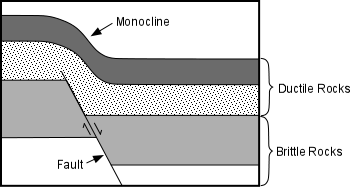
    It must be kept in mind, however that it's not just the crust that floats, it's the entire lithosphere.   So, the lithospheric mantle beneath continents also extends to deeper levels and is thicker under mountain ranges than normal.  Because the lithosphere is floating in the asthenosphere which is more ductile than the brittle lithosphere, the soft asthenosphere can flow to compensate for any change in thickness of the crust caused by erosion or deformation.

    The Principle of isostasy states that there is a flotational balance between low density rocks and high density rocks. i.e. low density crustal rocks float on higher density mantle rocks. The height at which the low density rocks float is dependent on the thickness of the low density rocks. Continents stand high because they are composed of low density rocks (granitic composition). Ocean basins stand low, because they are composed of higher density basaltic and gabbroic rocks.

    Isostasy is best illustrated by effects of glaciation. During an ice age crustal rocks that are covered with ice are depressed by the weight of the overlying ice. When the ice melts, the areas previously covered with ice undergo uplift.

    Mountains only grow so long as there are forces causing the uplift.   As mountains rise, they are eroded.  Initially the erosion will cause the mountains to rise higher as a result of isostatic compensation.  But, eventually, the weight of the mountain starts to depress the lower crust and sub-continental lithosphere to levels where they start to heat up and become more ductile.  This hotter lithosphere will then begin to flow outward away from the excess weight and the above will start to collapse. 

    The hotter rocks could eventually partially melt, resulting in igneous intrusions as the magmas move to higher levels, or the entire hotter lower crust could begin to rise as a result of their lower density.   These processes combined with erosion on the surface result in exhumation, which causes rocks from the deep crust to eventually become exposed at the surface.

    Causes of Mountain Building

    There are three primary causes of mountain building.

    1. Convergence at convergent plate boundaries.
    2. Continental Collisions.
    3. Rifting
    • Convergent Plate Margins

      When oceanic lithosphere subducts beneath continental lithosphere magmas generated above the subduction zone rise, intrude, and erupt to form volcanic mountains.   The compressional stresses generated between the trench and the volcanic arc create fold-thrust mountain belts, and similar compression behind the arc create a fold-thrust belt resulting in mountains.   Mountains along the margins of western North and South America, like the Andes and the Cascade range formed in this fashion. 

      Island arcs off the coast of continents can get pushed against the continent.  Because of their low density, they don't subduct, but instead get accreted to the edge of the continent.  Mountain ranges along the west coast of North America formed in this fashion (see figure 11.20 in your text). 
    • Continental Collisions

      Plate tectonics can cause continental crustal blocks to collide. When this occurs the rocks between the two continental blocks become folded and faulted under compressional stresses and are pushed upward to form fold-thrust mountains. The Himalayan Mountains (currently the highest on Earth) are mountains of this type and were formed as a result of the Indian Plate colliding with the Eurasian plate. Similarly the Appalachian Mountains of North America and the Alps of Europe were formed by such processes.

    • Rifting

      Continental Rifting occurs where continental crust is undergoing extensional deformation.   This results in thinning of the lithosphere and upwelling of the asthenosphere which results in uplift.  The brittle lithosphere responds by producing normal faults where blocks of continental lithosphere are uplifted to form grabens or half grabens.   The uplifted blocks are referred to a fault-block mountains.

      The Basin and Range province in the western United states formed in this manner, including the Sierra Nevada on its western edge and the Grand Tetons in Wyoming..  


    Cratons and Orogens

    The continents can be divided into two kinds of structural units

    • Cratons form the cores of the continents. These are portions of continental crust that have attained isostatic and tectonic stability and have cooled substantially since their formation. They were formed and were deformed more than a billion years ago and are the oldest parts of the continents. The represent the deep roots of former mountains and consist of metamorphic and plutonic igneous rocks, all showing extensive evidence of deformation.

    • Orogens are broad elongated belts of deformed rocks that are draped around the cratons. They appear to be the eroded roots of former mountain belts that formed by continent - continent collisions. Only the youngest of these orogens still form mountain ranges (see figure 13.10) in your text).

    The observation that the orogens are generally younger towards the outside of any continent suggests that the continents were built by collisions of plates that added younger material to the outside edges of the continents, and is further evidence that plate tectonics has operated for at least the last 2 billion years.

    Case Study of the Appalachian Mountains


    The Appalachian Mountain Range extending from northern Alabama to Nova Scotia have a history that dates back about 1 billion years.  This history will be discussed in class and is covered in section 11.8 of your textbook.


    Questions on this material that could be asked on an exam.


    1. Define the following: (a) fault breccia, (b) slickensides, (c) mylonite, (d) fold axis, (e) axial plane, (f) plunging fold, (g) orogenesis, (h) isostasy.

    2. Explain in words or drawings the essential aspects of the following features: (a) normal fault, (b) reverse fault, (c) thrust fault, (d) horsts and grabens, (e) half grabens.

    3. Draw cross sections of an anticline and a syncline and label the fold hinge, fold limbs, fold axis, and the axial plane of each.

    4. What is the difference between a flexural fold and a flow fold?

    5. Is it possible for faults to cause folds or folds to cause faults?  Explain.

    6. In which settings are mountains formed and what kind of mountains are formed in each?

    7. What processes are involved in exhumation and what is the final result of exhumation?

    8. Explain how crustal thickness varies on the Earth and how we know this?

    9. Why is metamorphic foliation often parallel to the axial planes of folds?

    10. For each of the following types of mountain ranges give some examples: (a) fold-thrust, (b) block-fault, (c) volcanic

    Return to EENS 1110 Page