| EENS 1110 | Physical Geology |
| Tulane University | Prof. Stephen A. Nelson |
Continental Drift, Sea Floor Spreading and Plate Tectonics |
|
|
|
| Plate Tectonics is a theory developed in the late 1960s, to explain how the outer
layers of the Earth move and deform. The theory has caused a revolution in the way we
think about the Earth. Since the development of the theory, geologists
have had to reexamine almost every aspect of Geology. Plate tectonics has proven to be so
useful that it can predict geologic events and explain almost all aspects of what we see
on the Earth.
Tectonic Theories Tectonic theories attempt to explain why mountains, earthquakes, and volcanoes occur where they do, the ages of deformational events, and the ages and shapes of continents and ocean basins.
Alfred Wegner was a German Meteorologist in the early 1900s who studied ancient climates. Like most people, the jigsaw puzzle appearance of the Atlantic continental margins caught his attention. He put together the evidence of ancient glaciations and the distribution of fossil to formulate a theory that the continents have moved over the surface of the Earth, sometimes forming large supercontinents and other times forming separate continental masses. He proposed that prior to about 200 million years ago all of the continents formed one large land mass that he called Pangea (see figures on pages 56 to 59 in your text). The weakness of Wegner's theory, and the reason it was not readily accepted by geologists was that he proposed that the continents slide over ocean floor. Geophysicists disagreed, stating the ocean floor did not have enough strength to hold the continents and too much frictional resistance would be encountered. In 1950s and 1960s, studies of the Earth's magnetic field and how it varied through time (paleomagnetism) provided new evidence that would prove that the continents do indeed drift. In order to understand these developments, we must first discuss the Earth's magnetic field and the study of Paleomagnetism. The Earth's Magnetic Field and Paleomagnetism |
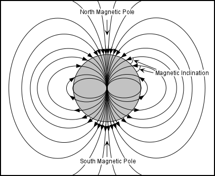
| The Earth has a magnetic field that causes a compass needle to always point toward the North magnetic pole, currently located near the rotation pole. The Earth's magnetic field is what would be expected if there were a large bar magnet located at the center of the Earth (we now know that this is not what causes the magnetic field, but the analogy is still good). The magnetic field is composed of lines of force as shown in the diagram here. | |
| A compass needle or a magnetic weight suspended from a string, points along these lines of force. Note that the lines of force intersect the surface of the Earth at various angles that depend on position on the Earth's surface. This angle is called the magnetic inclination. The inclination is 0o at the magnetic equator and 90o at the magnetic poles. Thus, by measuring the inclination and the angle to the magnetic pole, one can tell position on the Earth relative to the magnetic poles. |
| In the 1950s it was discovered that when magnetic minerals cool below a temperature called the Curie Temperature, domains within the magnetic mineral take on an orientation parallel to any external magnetic field present at the time they cooled below this temperature. | 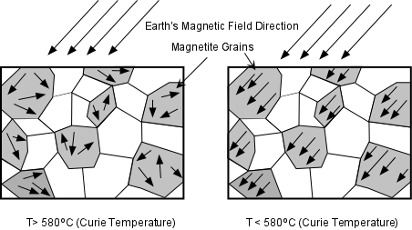 |
| At temperatures above the Curie Temperature, permanent magnetization of materials is not possible. Since the magnetic minerals take on the orientation of the magnetic field present during cooling, we can determine the orientation of the magnetic field present at the time the rock containing the mineral cooled below the Curie Temperature, and thus, be able to determine the position of the magnetic pole at that time. This made possible the study of Paleomagnetism (the history of the Earth's magnetic field). Magnetite is the most common magnetic mineral in the Earth's crust and has a Curie Temperature of 580oC |
| Initial studies of the how the position of the Earth's magnetic pole varied with time were conducted in Europe. These studies showed that the magnetic pole had apparently moved through time. When similar measurements were made on rocks of various ages in North America, however, a different path of the magnetic pole was found. | 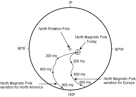 |
|
This either suggested that (1) the Earth has had more than one magnetic pole at various times in the past (not likely), or (2) that the different continents have moved relative to each other over time. Studies of ancient pole positions for other continents confirmed the latter hypothesis, and seemed to confirm the theory of Continental Drift.
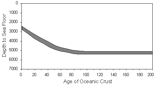
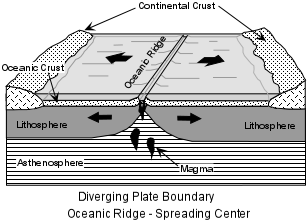
Sea-Floor Spreading During World War II, geologists employed by the military carried out studies of the sea floor, a part of the Earth that had received little scientific study. The purpose of these studies was to understand the topography of the sea floor to find hiding places for both Allied and enemy submarines. The topographic studies involved measuring the depth to the sea floor. These studies revealed the presence of two important topographic features of the ocean floor:
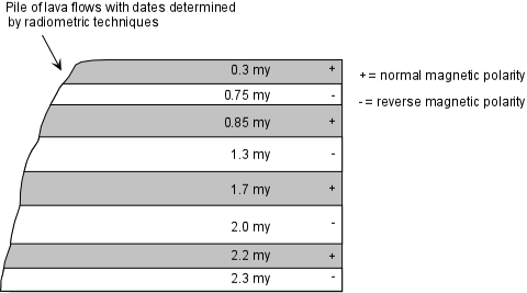
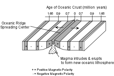
Another type of study involved towing a magnetometer (for measuring magnetic materials) behind ships to detect submarines. The records from the magnetometers, however, revealed that there were magnetic anomalies on the sea floor, with magnetic high areas running along the oceanic ridges, and parallel bands of alternating high and low magnetism on either side of the oceanic ridges. Before these features can be understood, we need to first discuss another development in the field of Paleomagnetism - the discovery of reversals of the Earth's magnetic field and the magnetic time scale .
|
|
|
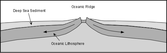
Vine, Matthews, and Morely put this information together with the bands of magnetic stripes on the sea floor and postulated that the bands represents oppositely polarized rocks on either side of the oceanic ridges, and that new oceanic crust and lithosphere was created at the oceanic ridge by eruption and intrusion of magma. As this magma cooled it took on the magnetism of the magnetic field at the time. When the polarity of the field changed new crust and lithosphere created at the ridge would take on the different polarity. This hypothesis led to the theory of sea floor spreading. |
 |
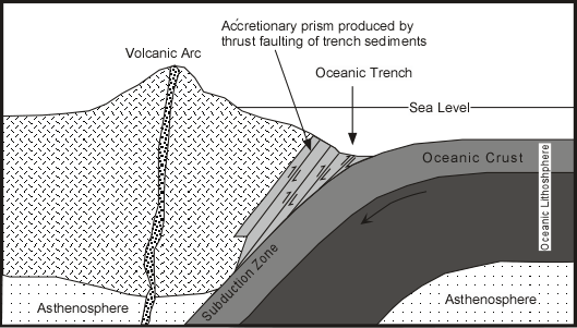
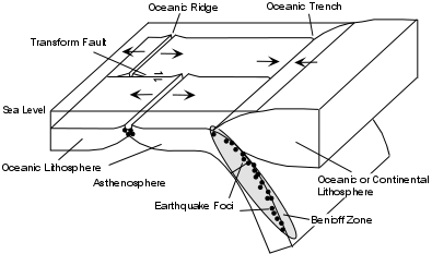
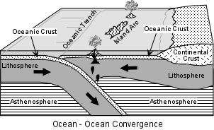
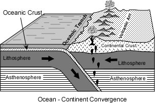
If new oceanic crust and lithosphere is continually being created at the oceanic ridges, the oceans should be expanding indefinitely, unless there were a mechanism to destroy the oceanic lithosphere. Benioff zones and the oceanic trenches provided the answer: Oceanic lithosphere returns to the mantle by sliding downward at the oceanic trenches (subducting). Because oceanic lithosphere is cold and brittle, it fractures as it descends back into the mantle. As it fractures it produces earthquakes that get progressively deeper.
|
|
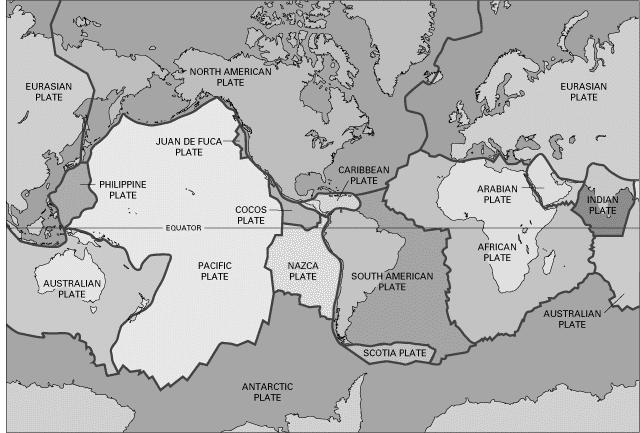
Plate Tectonics By combining the sea floor spreading theory with continental drift and information on global seismicity, the new theory of Plate Tectonics became a coherent theory to explain crustal movements. Plates are composed of lithosphere, about 100 km thick, that "float" on the ductile asthenosphere. |
 |
|
While the continents do indeed appear to drift, they do so only because they are part of larger plates that float and move horizontally on the upper mantle asthenosphere. The plates behave as rigid bodies with some ability to flex, but deformation occurs mainly along the boundaries between plates.
|
The plate boundaries can be identified because they are zones along which earthquakes occur. Plate interiors have much fewer earthquakes. |
 |
|
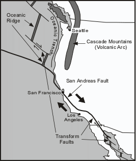
Types of Plate Boundaries There are three types of plate boundaries:
|
|
 |
|
|
|
|
|
|
|
|
|
|
 |
|
 |
|
|
|
|
|
|
 |
|
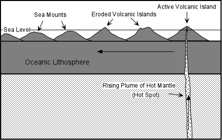
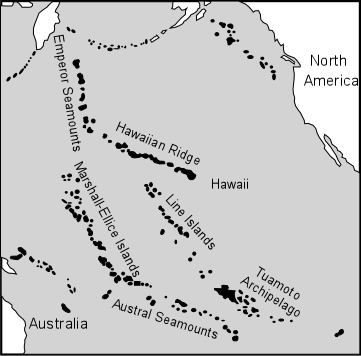
Triple Junctions occur at points where thee plates meet. Various combinations can exist, Two of these are shown in figure 4.10 in your text. Hot Spots Areas where rising plumes of hot mantle reach the surface, usually at locations far removed from plate boundaries are called hot spots. Because plates move relative to the underlying mantle, hot spots beneath oceanic lithosphere produce a chain of volcanoes. A volcano is active while it is over the vicinity of the hot spot, but eventually plate motion results in the volcano moving away from the plume and the volcano becomes extinct and begins to erode.
|
|
Because the Pacific Plate is one of the faster moving plates, this type of volcanism produces linear chains of islands and seamounts, such as the Hawaiian - Emperor chain, the Line Islands, the Marshall-Ellice Islands, and the Austral seamount chain. In this case the hot spot is currently located beneath the Big Island of Hawaii (the active volcanoes) at the south eastern end of the Hawaiian Ridge. Many other hot spots are known, most in the ocean basins. Where hot spots occur beneath continental lithosphere, large volumes of rhyolite are produced (See figure 4.11 in your text). |
 |
|
Hot Spots and Absolute Plate Velocities
|
|
By using hot spots and, more recently, the Global Positioning System (GPS), to determine absolute velocities, we find that the African Plate is almost stationary (expected because the African Plate is surrounded by oceanic ridges, and the Mid-Atlantic Ridge is moving toward the west. Furthermore, the Atlantic Ocean is getting bigger and the Pacific Ocean is getting smaller. |
|
Evolving Plate Boundaries Plate boundaries can evolve. New plate boundaries can form where mantle upwelling results in creating a rift in the crust and plate boundaries can die when when two plates of continental lithosphere collide. |
|
|
|
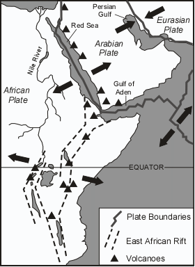
Continental Rifting - A new divergent plate boundary can form when continental lithosphere stretches, and thins to form a rift valley. As the rift widens and thins, upwelling asthenosphere can melt to produce magmas that start to create new oceanic lithosphere and spread the new plates apart (see figure 4.13 in your text).. An example of an where rifting may be forming a future diverging plate margin is an area of northeastern Africa, called the East African Rift Valley. Another area where this is apparently occurring is the Basin and Range Province of the Western U.S. |
 |
|
 |
|
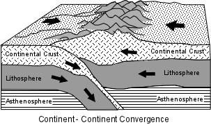
Currently the highest mountains in the world, the Himalayas represent this kind of event. The Himalayas resulted from a collision of the plate containing India with the plate containing Eurasia. This collision is still taking place and results in joining the two formerly separate plates. The occurrence of ancient fold -thrust mountain belts such as the Appalachian Mountains of the Eastern U.S., the Urals of Central Russia, and the Alps of southern Europe, are evidence of ancient continental collision margins. |
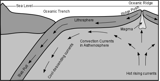
What Causes Plate Tectonics? From seismic wave velocities we know that the asthenosphere behaves in ductile manner, that is even though it is solid it can flow under stress and behave like a liquid. If this is the case, then it can also convect. Convection is a mode of heat transfer wherein the heat moves with the material. Convection is caused when material that occurs at a deeper level is heated to the point where it expands and becomes less dense than the material above it. When this occurs, the hot less dense material rises. In a confined space, rising hot material will eventually cool and become denser than its surroundings. This cool dense material must then sink. This gives rise to convection cells, with hot rising currents and cool descending currents. If the asthenosphere is in fact moving as a result of convection, then convection could be the mechanism responsible for plate tectonics. Hot rising currents would occur beneath oceanic ridges. |
Magma intruding into the ridge would push lithosphere apart at the ridge. As the new lithosphere cools, it will slide off the topographic high that results from the upwelling of the mantle and will eventually become cold and dense. This dense lithosphere will tend to pull the rest of the lithosphere downward. A combination of dragging the lithosphere along the top of the convection cell, ridge push, sliding, and slab pull all appear to be contributing factors to the cause of plate tectonics. There is still some debate as to whether asthenospheric convection drives the plates or the plates themselves drive plate tectonics. Until we have a better idea of what is happening in the mantle this debate will not likely be resolved. At least for now it appears that both convection and slab pull are the major factors (note that your textbook comes to a bit different conclusion. |
Questions on this material that could be asked on an exam
|