EENS 204

Natural Disasters

Tulane University

Prof. Stephen A. Nelson

Exceptional Weather (Part I)


Exceptional Weather

Here we cover weather related phenomenon, including severe thunderstorms, tornadoes, tropical cyclonic storms (hurricanes, typhoons, and cyclones), nor'easters, drought, and the causes and effects of El Niņo. We have already discussed the factors involved in the circulation of the atmosphere and oceans. Knowledge of the general atmospheric circulation patterns, the Coriolis effect, and circulation around high and low atmospheric pressure areas from the previous lecture is essential for understanding the material in this section.


Water and Heat

Water has one of the highest heat capacities of all known substances.  This means that it takes a lot of heat to raise the temperature of water by just one degree.  Water thus absorbs a tremendous amount of heat from solar radiation, and furthermore, because solar radiation can penetrate water easily, large amounts of solar energy are stored in the world's oceans. 


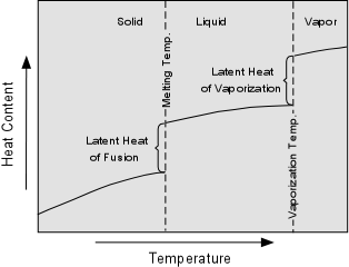
Further energy is absorbed by water vapor as the latent heat of vaporization, which is the heat required to evaporate water or change it from a liquid to a vapor.  This latent heat of vaporization is given up to the atmosphere when water condenses to form liquid water as rain.  If the rain changes to a solid in the form of snow or ice, it also releases a quantity of heat known as the latent heat of fusion. 

Thus, both liquid water and water vapor are important in absorbing heat from solar radiation and transporting and redistributing this heat around the planet.


LatentHeat.GIF (7555 bytes)


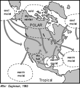
Air Masses
Due to general atmospheric circulation patterns, air masses containing differing amounts of heat and moisture move into and across North America.  Polar air masses, containing little moisture and low temperatures move downward from the poles.  Air masses that form over water are generally moist, and those that form over the tropical oceans are both moist and warm. Because of the Coriolis effect due to the Earth's rotation, air masses generally move across North America from west to east.  But, because of the differences in moisture and heat, the collision of these air masses can cause instability in the atmosphere.
AirMasses.GIF (20063 bytes)
 

Fronts and Mid-latitude Cyclones
Different air masses with different temperatures and moisture content, in general, do not mix when they run into each other, but instead are separated from each other along boundaries called fronts.

When cold air moving down from the poles encounters warm moist air moving up from the Gulf of Mexico, Pacific Ocean, or Atlantic Ocean, a cold front develops and the warm moist air rises above the cold front.  This rising moist air cools as it rises causing the condensation of water vapor to form rain or snow.  Note that the cold air masses tend to circulate around a low pressure center in a counterclockwise fashion in the northern hemisphere.  Such circulation around a low pressure center is called a mid-latitude cyclone Frontmap.GIF (11095 bytes)


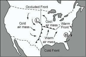
When warm air moving northward meets the cooler air to the north, a warm front forms.  As the warm air rises along a gently inclined warm front, clouds tend to form, and can also cause rain, but rain is less likely because the warm front is not as steep as a cold front.   If the rapidly moving cold front overtakes the warm front, an occluded front forms, trapping warm air above a layer of cold and cool air.  Mid-latitude cyclones and their associated fronts are responsible for such severe weather conditions as thunderstorms, snow storms and associated hail, lightening, and occasional tornadoes.
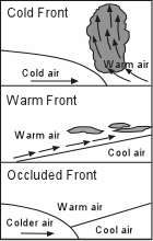
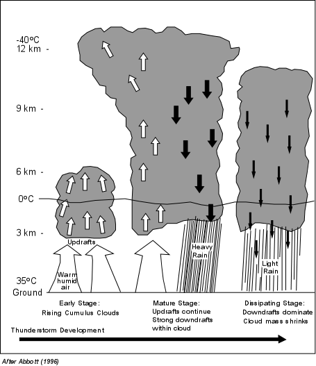
Thunderstorms
Thunderstorms occur anywhere that warm moist air has absorbed enough heat to make the air less dense than the surrounding air. This commonly occurs along cold fronts, but can occur in other places as well, particularly where daytime heating forms hot air near the Earth's surface. As the warm moist air rises it begins to cool and water begins to condense into tiny droplets that form clouds. Condensation of the water droplets in the clouds releases the latent heat of evaporation, adding heat to the rising air, thus decreasing its density and allowing it to rise to higher levels in the atmosphere. This rising air, called an updraft,  starts to build clouds to heights of up to 6 km. Further rising and cooling within the clouds causes more condensation, as well as the formation of ice crystals which release further latent heat and build cloud heights up to 12 km.  Eventually the water droplets and ice crystals in the clouds become so large that they can no longer be supported by the uprising air mass, and they begin to fall forming rapid downdrafts on the leading edge of the cloud.  In the mature stage of thunderstorm development updrafts and downdrafts operate side by side within the cloud.  This is the most dangerous stage of a thunderstorm because of the high winds accompanying the downdrafts, the heavy rain, as well as thunder, lightening, and possible hail and tornado development.  Eventually the cloud reaches the dissipating stage as the downdrafts drag in so much cool dry air that it prevents further updrafts of warm moist air. With lack of updrafts of warm moist air, the cloud begins to dissipate and eventually it stops raining

ThundStorms.GIF (36940 bytes)


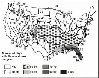
Thunderstorms can form as single cells, with only one cloud mass, or as multiple cells, with several clouds moving along a similar path.

Although thunderstorms can occur nearly everywhere, they show an unequal distribution through the United States.  Areas that receive the highest number of thunderstorms are areas where warm moist air moves northward from the Gulf of Mexico.  As seen in the figure to the right, areas in southwestern Florida have over 100 days per year with a thunderstorm


  • Hail - Hail is a rain of semi-spherical, concentrically layered ice balls that are dropped from some thunderstorms.  Hail rarely kills people, but it does heavy damage to agriculture, roofs, and automobiles.  The conditions necessary to form hail during a thunderstorm are:
  • Large thunderstorms with high cloud tops formed from hot moist rising air.

  • Upper level cold air with a large temperature contrast between the upper level air and the rising moist air.

  • Strong updrafts within the thunderstorm to keep hailstones suspended in the cloud while layers of ice are added to the stones.  When the stones become too large to be suspended by the cloud they fall to the surface as hail.

Although thunderstorms are most common along the Gulf coast, thunderstorms that produce hail are more common in the mid-continent region where temperature contrasts between upper air masses and the rising hot air are greater.  Hail can range from pea-size stones to grapefruit size stones.


  • Lightening - Lightening is the electrical discharge from clouds that causes thunder. Thus, lightening occurs from all thunderstorms.  Lightening is the major cause of forest fires and results in many deaths.  Deaths from lightening have a similar distribution to the occurrence of thunderstorms, with Florida having both the most thunderstorms and the most lightening deaths.

LightDeath.GIF (17544 bytes)

Deaths from lightening usually occur outdoors as seen in the following table:

Locations of U.S. Lightening Deaths, 1959 - 1980
Open fields, ball fields 26%
Under trees 15%
On boats & in water-related activity 12%
On tractors & heavy road equipment 6%
Golf courses 5%
Via telephone 1%
Unspecified 35%


    Lightening is caused by an imbalance of electrical charge between and within clouds and the ground.  Most of you have simulated lightening by walking across a carpet on a dry day and then touching a metal object like a door knob. Static electrical charge builds on your body and is discharged to the door knob as a bolt of electricity. During the buildup of a thundercloud, charged particles of water droplets and ice become separated in the cloud. Positively charged particles are moved to the top of the cloud and negatively charged particles are moved to the bottom of the cloud. 

Lightening.GIF (13892 bytes)

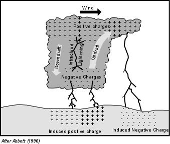
    The thundercloud then begins to interact with the ground.  The negatively charged part of the cloud induces a build-up of positive charges on the ground.  Similarly beneath the upper positively charged part of the cloud negative charges are induced in the ground below. When the difference in voltage between the oppositely charged parts of the cloud and the ground become great enough, the electricity is discharged as a bolt of lightening.

    Note that lightening can travel from the cloud to the ground, from the ground to the cloud, and within the cloud itself.  Lightening travels at speeds of about 100,000 miles per hour, and usually includes several strokes that all occur within about 1/2 of a second.  The discharge of electricity during a bolt of lightening heats up the air surrounding the bolt causing rapid expansion of the air.  It is this rapid expansion of the air that causes the sound we call thunder.
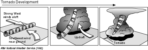
 

Tornadoes
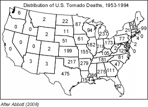
Tornadoes are funnel shaped clouds that are associated with thunderstorms.  Tornadoes have wind velocities higher than hurricanes (up to 500 km/hr [318 miles per hour]), but affect a much smaller area than hurricanes.  Over 70% of the tornadoes that occur on Earth occur in the great plains of the United States.  Between 1916 and 1990 tornadoes caused 11,900  deaths in the United States, an average of 159 deaths per year.  TornadoDeaths.GIF (16697 bytes)
 
  • Tornado Development - A tornado develops within a severe thunderstorm when there is an excessive amount of vertical wind shear.  Vertical wind shear is when upper level winds are blowing at a high velocity relative to lower level winds.  Prior to the development of the thunderstorm strong high level winds blowing to the west initiates a spinning flow near the Earth's surface.  This spinning flow takes the form of an invisible horizontally oriented cylinder.  As the thunderstorm develops, strong updrafts of warm air lifts this rotating air into a more vertical position within the thundercloud, causing part of the thundercloud to rotate around the a vortex in a counterclockwise direction.  Tornadoes form within this rotating air, usually at the rear flank of the thunderstorm, and extend down from the thundercloud occasionally reaching the surface.  They travel at velocities between stationary and 110 km/hr, with cyclonic wind speeds up to 500 km/hr as noted above.  The diameters of tornadoes range from a few tens of meters up to 1.5 km.  They do not often remain in contact with the ground for long periods of time, but can skip across the surface as the thunderstorm moves along.


 TornadoDev.GIF (24641 bytes)

 
  • Tornado Intensity  - The intensity of a tornado is classified by the Fujita tornado intensity scale shown in the table below.


Fujita Tornado Intensity Scale
F0 - F1 F2 - F3 F4 - F5
Weak Tornado Strong Tornado Violent Tornado
F0 40-72 mph Gale tornado Light damage. Some damage to chimneys; break branches off trees; push over shallow-rooted trees; damage sign boards.
F1 73-112 mph Moderate tornado Moderate damage. The lower limit is the beginning of hurricane wind speed; peel surface off roofs; mobile homes pushed off foundations or overturned; moving autos pushed off the roads.
F2 113-157 mph Significant tornado Considerable damage. Roofs torn off frame houses; mobile homes demolished; boxcars pushed over; large trees snapped or uprooted; light-object missiles generated.
F3 158-206 mph Severe tornado. Severe damage. Roofs and some walls torn off well-constructed houses; trains overturned; most trees in forest uprooted; heavy cars lifted off the ground and thrown.
F4 207-260 mph Devastating tornado Devastating damage. Well-constructed houses leveled; structures with weak foundations blown off some distance; cars thrown and large missiles generated.
F5 261-318 mph Incredible tornado. Incredible damage. Strong frame houses lifted off foundations and carried considerable distance to disintegrate; automobile sized missiles fly through the air in excess of 100 meters(109 yds); trees debarked; incredible phenomena will occur.
F6
-
F12
319 mph - MACH 1
(the speed of sound)
The maximum wind speeds of tornadoes are not expected to reach the F6 wind speeds.
  • Tornado Frequency - Tornadoes have occurred in every state of the U.S. except Alaska.  Because they are associated with strong thunderstorms, the frequency of tornadoes is closely related to the areas that have lots of thunderstorms, but also occur predominantly in the plains states where cold air descending from above the Rocky Mountains encounters warm air moving northward from the Gulf of Mexico.  It is these contrasting air masses and their common paths of circulation which give rise to both the thunderstorms and the tornadoes. 
USTornadoes.GIF (17435 bytes)


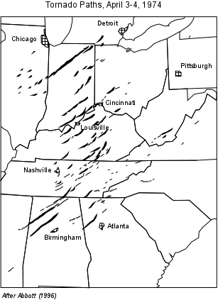
    Tornadoes are most common during the spring and summer months.  They often occur as swarms associated with cold fronts that move across the U.S. from west to east.  One such swarm occurred between April 3rd and 4th, 1974.  In 16 hours over 147 tornadoes touched down between Mississippi and Pennsylvania, including six tornadoes of F-5 intensity.  This swarm killed 307 people, injured over 6,000, and caused property damage of about $600 million.  Note the generally northeast trending tracks of the tornadoes, which is typical of most tornadoes in the U.S.

TornOutbreak.GIF (22833 bytes)
  • Tornado Damage - Tornado damage is caused by the high wind speed and high difference in atmospheric pressure between the tornado and its surroundings.  The rotating winds can knock down weaker structures, and the extremely low pressure inside the tornado generates strong pressure differences between the inside and outside of buildings.  This pressure difference causes roofs to be lifted and removed.  The high winds pick up smaller objects including small structures, animals, people, cars, and especially mobile homes, and can carry these objects up to several kilometers.  The debris picked up by the winds become rapidly moving projectiles that can become lethal when hurled against a human body.

     
  • Tornado Prediction and Warning - Tornadoes cannot be predicted with precision.   However, when strong thunderstorm activity is detected, a tornado watch is generally issued for all areas that may fall in the path of the thunderstorm.  Doppler radar can detect rotating motion within a thunderstorm and when this is detected, or a tornado is actually observed, a tornado warning is issued for all areas that may fall in the path of the thunderstorm. 


Tornado Safety (from the Federal Emergency Management Agency, FEMA)
  • If at home:
    • Go at once to the basement, storm cellar, or the lowest level of the building.

    • If there is no basement, go to an inner hallway or a smaller inner room without windows, such as a bathroom or closet.

    • Get away from the windows.

    • Go to the center of the room. Stay away from corners because they tend to attract debris.

    • Get under a piece of sturdy furniture such as a workbench or heavy table or desk and hold on to it. Use arms to protect head and neck.

    • If in a mobile home, get out and find shelter elsewhere.

  • If at work or school:
    • Go to the basement or to an inside hallway at the lowest level.

    • Avoid places with wide-span roofs such as auditoriums, cafeterias, large hallways, or shopping malls.

    • Get under a piece of sturdy furniture such as a workbench or heavy table or desk and hold on to it. Use arms to protect head and neck.

  • If outdoors:
    • If possible, get inside a building.

    • If shelter is not available or there is no time to get indoors, lie in a ditch or low-lying area or crouch near a strong building. Be aware of the potential for flooding.   Use arms to protect head and neck.

  • If in a car:
    • Never try to out drive a tornado in a car or truck. Tornadoes can change direction quickly and can lift up a car or truck and toss it through the air.

    • Get out of the car immediately and take shelter in a nearby building. If there is no time to get indoors, get out of the car and lie in a ditch or low-lying area away from the vehicle. Be aware of the potential for flooding.

  • After the tornado:
    • Help injured or trapped persons  Give first aid when appropriate. Don't try to move the seriously injured unless they are in immediate danger of further injury. Call for help.

    • Turn on radio or television to get the latest emergency information.

    • Stay out of damaged buildings. Return home only when authorities say it is safe.

    • Use the telephone only for emergency calls.

    • Clean up spilled medicines, bleaches, or gasoline or other flammable liquids immediately.

    • Leave the buildings if you smell gas or chemical fumes.

    • Take pictures of the damage--both to the house and its contents--for insurance purposes.

    • Remember to help your neighbors who may require special assistance--infants, the elderly, and people with disabilities.

  • Inspecting utilities in a damaged home:

    • Check for gas leaks--If you smell gas or hear a blowing or hissing noise, open a window and quickly leave the building. Turn off the gas at the outside main valve if you can and call the gas company from a neighbor's home.

    • If you turn off the gas for any reason, it must be turned back on by a professional.

Mitigation of Tornado Disasters

Because tornadoes can strike anywhere and anytime there are thunderstorms, the best mitigation is for an educated populace to be aware of the conditions under which tornadoes develop and heed any tornado watches or warnings that are issued by a responsible agency, and practice the tornado safety tips listed above.  The only other mitigation that can reduce the damage produced by tornadoes is building codes that require structures to be constructed with extra reinforcing of wood frames and masonry.


References

Return to EENS 204 Homepage